IMAGES TAKEN NEAR TO
Radford Boulevard, NOTTINGHAM, NG7 3BN
Introduction
This page details the photographs taken nearby to Radford Boulevard, NG7 3BN by members of the Geograph project.
The Geograph project started in 2005 with the aim of publishing, organising and preserving representative images for every square kilometre of Great Britain, Ireland and the Isle of Man.

There are currently over 7.5m images from over14,400 individuals and you can help contribute to the project by visiting https://www.geograph.org.uk
Image Map
Images are licensed for reuse under creativecommons.org/licenses/by-sa/2.0
Notes
- Clicking on the map will re-center to the selected point.
- The higher the marker number, the further away the image location is from the centre of the postcode.
Image Listing (171 Images Found)
Images are licensed for reuse under creativecommons.org/licenses/by-sa/2.0
Image
Details
Distance
1
Denman Street Central
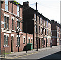
Until the clearance schemes of the late 1960s, Denman Street ran almost the whole length of Radford, from St Peter's Street in the west uphill almost to Canning Circus. It has now been truncated and partly pedestrianised. When I was growing up in these parts in the 1950s, Denman Street was quite a shopping centre. Three-storey houses and shops were a Nottingham speciality in the late Victorian period.
Image: © John Sutton
Taken: 21 Jul 2012
0.03 miles
2
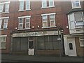
Ruchis Nursery World, Denham Street Central
This shop had stood derelict for some time at this point. It has since been converted into two houses.
Image: © Bryn Holmes
Taken: 17 Feb 2019
0.04 miles
3
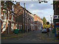
Denman Street Central
Denman Street used to run right across Radford from Alfreton Road to St Peter's Street, but was truncated as a result of redevelopment in the early 70s. This is the only remaining section of traditional terraced housing. See also Image
Image: © Alan Murray-Rust
Taken: 7 Nov 2008
0.05 miles
5
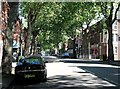
Leafy Radford
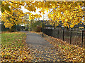
Radford Boulevard, near Denman Street corner, looking towards Alfreton Road and Gregory Boulevard. Castle, Lenton, Radford and Gregory Boulevards, laid out in the 1880s, were a piece of enlightened town planning, forming an early ring road, lined with genteel villas and some industrial premises, on the west side of the city.
Image: © John Sutton
Taken: 21 Jul 2012
0.05 miles
6
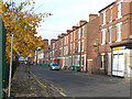
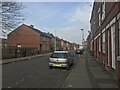
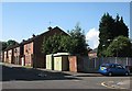
Forster Street
These three-storey terraces are typical of Radford, and would have been occupied principally by workers in the textile and tobacco industries in the area.
Image: © Alan Murray-Rust
Taken: 7 Nov 2008
0.05 miles
7
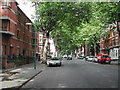
Radford Boulevard, Nottingham
in Victorian times a very fashionable area of Nottingham. Not so now, but still nice with all the trees.
Image: © Tom Courtney
Taken: 9 Sep 2005
0.06 miles
9
Denman Street West
During 1970s redevelopment this section of the street was converted to a pedestrian walkway, partly to reduce through traffic.
Image: © Alan Murray-Rust
Taken: 7 Nov 2008
0.07 miles
10
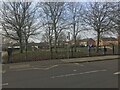
Forster Street: newer houses
These houses replaced the original Victorian ones like those shown in Image Between the trees to the right is the plume from Ratcliffe-on-Soar power station, about seven miles away to the south west.
Image: © John Sutton
Taken: 21 Jul 2012
0.07 miles