IMAGES TAKEN NEAR TO
Montpelier Road, NOTTINGHAM, NG7 2JW
Introduction
This page details the photographs taken nearby to Montpelier Road, NG7 2JW by members of the Geograph project.
The Geograph project started in 2005 with the aim of publishing, organising and preserving representative images for every square kilometre of Great Britain, Ireland and the Isle of Man.

There are currently over 7.5m images from over14,400 individuals and you can help contribute to the project by visiting https://www.geograph.org.uk
Image Map
Images are licensed for reuse under creativecommons.org/licenses/by-sa/2.0
Notes
- Clicking on the map will re-center to the selected point.
- The higher the marker number, the further away the image location is from the centre of the postcode.
Image Listing (326 Images Found)
Images are licensed for reuse under creativecommons.org/licenses/by-sa/2.0
Image
Details
Distance
2
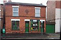
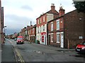
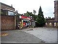
W. Coates and Sons, Montpelier Street
The current home of the successors to what was a significant firm of rope manufacturers for industrial and other purposes. The following is a resume of an article in the Lenton Times (journal of the Lenton Local History Society) for October 2003:
"William Coates set up in business as a ropemaker in 1840 and established a number of ropemaking operations in the Nottingham area. Following his father's death in 1894, Herbert Coates took over the business and decided that he needed to incorporate the latest technology if he were to keep ahead of his competitors. So in 1903 he bought an industrial property in Spring Close which had additional land attached to it. Here he had a huge indoor ropewalk built and installed the most up-to-date steam-driven machinery. For reasons which are explored in the article the company was eventually forced into liquidation in the mid-1930's. Their city centre premises were closed down, the work force laid off, the Lenton premises put up for sale and most of the machinery either auctioned off or sold for scrap. In due course most of the premises were acquired by W.J. Simms, Sons & Cooke Ltd. When Herbert Coates died in 1949 W.J. Coates & Sons found themselves with little option but to sell their remaining Spring Close properties to Simms, Sons & Cooke and move elsewhere. The article concludes by bringing the story up to date and recounts how Stewart Coates, great grandson of the original founder, continues to operate the business from 10 Montpelier Road."
Old OS maps show a rope and twine factory behind houses on the opposite side of Montpelier Road to the current business which appears to date from around the period when the spring Close property was sold, as outlined in the article, but it's not clear whether this was part of the business. (Spring Close was in the area now occupied by the Queens Medical Centre.)
Image: © Alan Murray-Rust
Taken: 21 Jun 2012
0.01 miles
3
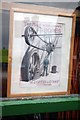
'The man who knows the ropes'
Advertising image from the early 20th century in the window of the Coates and Sons shop http://www.geograph.org.uk/photo/3006216 .
Image: © Alan Murray-Rust
Taken: 21 Jun 2012
0.01 miles
4
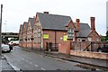
Dunkirk and Old Lenton Community Centre
Housed in the former Dunkirk Primary School which relocated to neighbouring Marlborough Street.
Image: © Alan Murray-Rust
Taken: 21 Jun 2012
0.01 miles
6
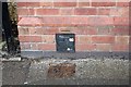
OS Bench Mark, Dunkirk Community Centre
The horizontal bar is clean, but there is no evidence of even the top of an arrow behind the gas valve plate. Even this is quite old, and I would have thought unlikely to have been sited to cover the mark. Is the bench mark simply the horizontal cut?
Image: © Alan Murray-Rust
Taken: 21 Jun 2012
0.02 miles
7
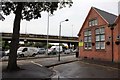
Dunkirk and Old Lenton Community Centre
The gable of the building with the ring road flyover beyond.
The bench mark in http://www.geograph.org.uk/photo/3004935 is at the far end of the building.
Image: © Alan Murray-Rust
Taken: 21 Jun 2012
0.02 miles
8
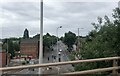
The A6005
From the A52, which flies over the roundabout
Image: © Eirian Evans
Taken: 30 Jul 2022
0.03 miles
9
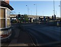
Beeston Road (A6005) entering Dunkirk Roundabout below Clifton Boulevard (A52)
Image: © Tim Heaton
Taken: 11 Nov 2012
0.03 miles
10
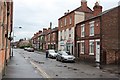
Montpelier Road, Dunkirk
The oldest part of the area known as Dunkirk, the name deriving from a local farm.
Image: © Alan Murray-Rust
Taken: 21 Jun 2012
0.03 miles