IMAGES TAKEN NEAR TO
Church Street, NOTTINGHAM, NG7 2FF
Introduction
This page details the photographs taken nearby to Church Street, NG7 2FF by members of the Geograph project.
The Geograph project started in 2005 with the aim of publishing, organising and preserving representative images for every square kilometre of Great Britain, Ireland and the Isle of Man.

There are currently over 7.5m images from over14,400 individuals and you can help contribute to the project by visiting https://www.geograph.org.uk
Image Map
Images are licensed for reuse under creativecommons.org/licenses/by-sa/2.0
Notes
- Clicking on the map will re-center to the selected point.
- The higher the marker number, the further away the image location is from the centre of the postcode.
Image Listing (219 Images Found)
Images are licensed for reuse under creativecommons.org/licenses/by-sa/2.0
Image
Details
Distance
1
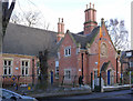
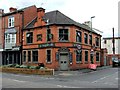
Former Conservative Club, Church Street
Although the sign at the far end is still looking fresh, the club has been closed for some time and the buildings showing signs of decay.
Image: © Alan Murray-Rust
Taken: 22 Dec 2013
0.02 miles
2
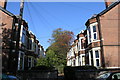
Lenton Boulevard
Lenton Boulevard is the Heart of the New Lenton district.
A high proportion of the population are students 27% in NG7 (postcode) as a whole (the average for the whole of NG is 4% and the national average 3.4%). The average age of the residents in NG7 is 23 – one of the youngest in the country.
Image: © David Lally
Taken: 23 Oct 2007
0.03 miles
3
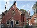
Sri Guru Teg Bahadur Gurdwara, Church Street, Lenton, Nottingham
A Sikh gurdwara.
Wikipedia article on Gurdwaras https://en.wikipedia.org/wiki/Gurdwara
Image: © Jeremy Bolwell
Taken: 10 Aug 2020
0.03 miles
4
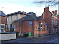
Sikh Temple, Church Street, Lenton
Formerly a Church School, built as the date stone shows in 1841. Having at one time been painted, (compare with http://www.geograph.org.uk/photo/1822911 ) this building has reverted to its natural brickwork, probably due to it being a Listed Building. The railings in front of the building are contemporary with it and are separately Listed for group value.
Image: © Alan Murray-Rust
Taken: 22 Dec 2013
0.04 miles
7
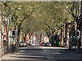
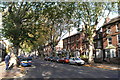
Leafy Lenton
A spring-morning view through a zoom lens up Lenton Boulevard, towards Derby Road. Castle Boulevard, Lenton Boulevard, Radford Boulevard and Gregory Boulevard, laid out in the 1880s, formed a big loop round the western side of the city, an early form of inner-ring road leading from the foot of Castle Rock to Mansfield Road.
According to his sister Lois, speaking in 1981, the Great War air ace Albert Ball VC (1896-1917) was born at No 32, in the distance on the right, but this is not confirmed by other sources - and there is no plaque. The Ball family later moved to a grand house in The Park Estate - see Image
Image: © John Sutton
Taken: 16 Apr 2011
0.04 miles
10
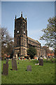
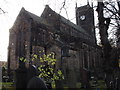
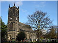
Holy Trinity church
By H.I.Stevens in 1842 including a 12th century font from Lenton Priory
Image: © Richard Croft
Taken: 23 Apr 2010
0.04 miles