IMAGES TAKEN NEAR TO
Kirtley Drive, NOTTINGHAM, NG7 1LD
Introduction
This page details the photographs taken nearby to Kirtley Drive, NG7 1LD by members of the Geograph project.
The Geograph project started in 2005 with the aim of publishing, organising and preserving representative images for every square kilometre of Great Britain, Ireland and the Isle of Man.

There are currently over 7.5m images from over14,400 individuals and you can help contribute to the project by visiting https://www.geograph.org.uk
Image Map
Images are licensed for reuse under creativecommons.org/licenses/by-sa/2.0
Notes
- Clicking on the map will re-center to the selected point.
- The higher the marker number, the further away the image location is from the centre of the postcode.
Image Listing (226 Images Found)
Images are licensed for reuse under creativecommons.org/licenses/by-sa/2.0
Image
Details
Distance
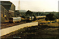
2
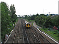
Mansfield Junction
A Sleaford train approaching Nottingham along the main line to Derby and Leicester, seen from Castle Bridge Road. The Leen Valley line to Mansfield and Worksop diverges to the right. The tower of the Trent Building at Nottingham University is on the skyline in the centre. For the view towards the city from here, see Image
Image: © John Sutton
Taken: 20 Jul 2012
0.03 miles
3
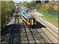
Mansfield Junction
A cl.158 DMU operated by East Midlands Trains approaches Nottingham from the Beeston direction. Compare with Image taken in 2012.
Image: © Stephen McKay
Taken: 18 Apr 2015
0.03 miles
5
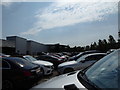
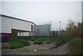
Car park at Mercedes, Enterprise Way, Nottingham
A car dealership car park on a business park.
Image: © Jeremy Bolwell
Taken: 10 Aug 2020
0.08 miles
7
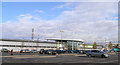
Homebase - Nottingham
The only one of the new buildings around this, now called ng2, business park currently shown on the map. It's been open at least 4 years.
As of date of submission the aerial view on map.live.com still shows a large factory on this site. This was the former Royal Ordnance factory a site dedicated to the history of which can be found here http://www.rofnottingham.co.uk/02_history_01.htm (link courtesy of Derek Harper, web searcher extraordinaire!)
The business park takes its name from the postcode of the area, but is written in lowercase with a superscript 2 as in ng squared, what ever that's supposed to mean!.
Image: © David Lally
Taken: 3 Dec 2007
0.09 miles
9
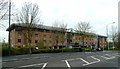
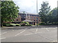
Holiday Inn, Nottingham
The hotel is about a mile distant from the city centre which can be reached via the towpath of the Nottingham Beeston Canal. And very well located near the junction of four grid squares!
Image: © Graham Hogg
Taken: 8 Apr 2012
0.10 miles
10

Holiday Inn hotel and roundabout in Lawrence Way
Image: © David Martin
Taken: 10 Sep 2012
0.11 miles