IMAGES TAKEN NEAR TO
Tennis Drive, NOTTINGHAM, NG7 1AE
Introduction
This page details the photographs taken nearby to Tennis Drive, NG7 1AE by members of the Geograph project.
The Geograph project started in 2005 with the aim of publishing, organising and preserving representative images for every square kilometre of Great Britain, Ireland and the Isle of Man.

There are currently over 7.5m images from over14,400 individuals and you can help contribute to the project by visiting https://www.geograph.org.uk
Image Map
Images are licensed for reuse under creativecommons.org/licenses/by-sa/2.0
Notes
- Clicking on the map will re-center to the selected point.
- The higher the marker number, the further away the image location is from the centre of the postcode.
Image Listing (418 Images Found)
Images are licensed for reuse under creativecommons.org/licenses/by-sa/2.0
Image
Details
Distance
2
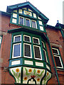
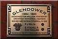
Detail of 27 Newcastle Drive, Nottingham
Timbered oriel and gable with painted sunflowers on a house by Watson Fothergill, 1884-85.
Full view: Image
Image: © Stephen Richards
Taken: 19 Jun 2012
0.02 miles
3
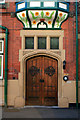
Doorway of 27 Newcastle Drive
Above is the decorated base of the central oriel window.
Image: © David Lally
Taken: 20 Apr 2010
0.02 miles
4
Glendower, 27 Newcastle Drive
Watson Fothergill house from 1884-5. Now offices I think.
Image: © David Lally
Taken: 20 Apr 2010
0.02 miles
6
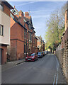
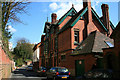
Park Estate: on Newcastle Drive
The private Park Estate was developed in the 19th century for the Duke of Newcastle. Its many Grade II listed buildings include Regency, mid- and late-Victorian houses and some modern ones. The land slopes steeply down from Derby Road (high above right) and The Ropewalk to the wide Trent Valley below.
Image: © John Sutton
Taken: 16 Apr 2022
0.02 miles
7

Roof Detail
27 Newcastle Drive, a Watson Fothergill house from 1884. Note the small window either side of the chimney on the outer gable.
Image: © David Lally
Taken: 20 Apr 2010
0.02 miles
8
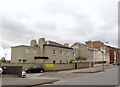
Houses on Derby Road
Early 19th century semi-detached houses just to the west of Canning Circus. The second and third pairs are both Listed Grade II, the latter now being a Spiritualist Church.
Image: © Alan Murray-Rust
Taken: 9 Feb 2014
0.04 miles
9
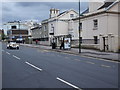
Nottingham - NG7 (Canning Circus area)
A row of white painted properties on Derby Road (A6200) are complemented by a dressed wedding car. Behind the bus stop is the home of the Nottingham First Spiritualist Church and in the distance is Canning Circus Police Station. Addendum (09/04/16) : This police station will have closed by 17/04/16, after which its services will be transferred to the new "Central Police Station" in Byron House, Maid Marion Way, NG1.
Image: © David Hallam-Jones
Taken: 5 May 2012
0.05 miles
10
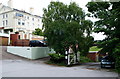
Nottingham - NG7 (Park)
A disused gateway/entrance into the exclusive Park Estate located at the side of and behind Canning Circus Police Station. Although the gate is permanently open, a series of notices advise motorists that the sloping road through the gate is for "Police Vehicles Only". There is however, access into the estate for pedestrians and cyclists via a narrow gate at the end of this short sloping road. A footpath that connects this area with Park Terrace can be seen commencing/terminating at the foot of the white painted wall. The white, Grade II-listed, C18th house - one of an original pair - has a Ropewalk address.
Image: © David Hallam-Jones
Taken: 10 Jun 2012
0.05 miles