1
Nottingham - NG7 (Park)
A huge house (now with multiple owners/tenants) in the middle section of Newcastle Drive. Note the tall (stained glass?) windows on this side elevation that presumably produce some very attractive results internally?
Image: © David Hallam-Jones
Taken: 10 Jun 2012
0.02 miles
2
Nottingham - NG7 (Park)
A disused gateway/entrance into the exclusive Park Estate located at the side of and behind Canning Circus Police Station. Although the gate is permanently open, a series of notices advise motorists that the sloping road through the gate is for "Police Vehicles Only". There is however, access into the estate for pedestrians and cyclists via a narrow gate at the end of this short sloping road. A footpath that connects this area with Park Terrace can be seen commencing/terminating at the foot of the white painted wall. The white, Grade II-listed, C18th house - one of an original pair - has a Ropewalk address.
Image: © David Hallam-Jones
Taken: 10 Jun 2012
0.02 miles
3
Nottingham - NG7 (Park)
This gateway - branching off the middle section of Newcastle Drive - provides pedestrian access to a disused entrance/exit in & out of the exclusive Park Estate. The former gate/s can be seen 100 feet (30 metres) ahead through this gate. Note the tall (stained glass?) windows in the side of this house in Newcastle Drive, an original Park Estate house that was probably constructed between 1820-1940.
Image: © David Hallam-Jones
Taken: 10 Jun 2012
0.02 miles
4
Nottingham - NG7 (Park)
The initial section of a footpath that commences off of Newcastle Terrace (near to the rear of Canning Cricus Police Station) and continues towards the junction of Newcastle Drive and Park Terrace, hugging as it does so, the rear garden walls of properties in The Ropewalk. On the right-hand side, behind the railings, pedestrians are able to look down upon Newcastle Drive.
Image: © David Hallam-Jones
Taken: 10 Jun 2012
0.03 miles
5
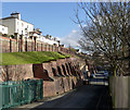
Newcastle Drive and Terrace
The cliff is a natural outcrop of the Bunter Sandstone, heavily buttressed in brick to prevent erosion and subsidence.
Image: © Alan Murray-Rust
Taken: 16 Feb 2014
0.03 miles
6
Nottingham - NG7 (Park)
A view along a section of Newcastle Drive looking in the direction of Park Terrace, both of which form part of this exclusive Estate. Sadly two garages, one in the distance and one under construction, together with the modern rendered property, can be said to detract from the dominant property here. "Glendower" was designed for William Foster by Fothergill Watson (who became Watson Fothergill in 1892) and was built between 1845-46. It seems likely that this is the William Foster who was the Lord Mayor between 1872-73.
Image: © David Hallam-Jones
Taken: 10 Jun 2012
0.03 miles
7
Nottingham - NG7 (Park)
Part of Newcastle Drive in the direction of Tattershall Drive on the exclusive Park Estate. "Glendower" was designed for William Foster by Fothergill Watson (who became Watson Fothergill in 1892) and was built between 1845-46. It seems possible that this was the William Foster who served as Lord Mayor between 1872-73. The house appears now to be occupied by several owners and/or tenants.
Image: © David Hallam-Jones
Taken: 10 Jun 2012
0.03 miles
8
Regency House, The Ropewalk
This is the 'front' side of the building seen in this view http://www.geograph.org.uk/photo/3845575
Image: © Alan Murray-Rust
Taken: 16 Feb 2014
0.03 miles
9
4&6 The Ropewalk
The main frontage of houses along the Ropewalk was on the sunny side rather than the road side.
Image: © Alan Murray-Rust
Taken: 16 Feb 2014
0.03 miles
10
Garages on Newcastle Drive
Carved out of the soft sandstone cliff.
Image: © David Lally
Taken: 20 Apr 2010
0.03 miles


