IMAGES TAKEN NEAR TO
Swale Close, NOTTINGHAM, NG6 9LZ
Introduction
This page details the photographs taken nearby to Swale Close, NG6 9LZ by members of the Geograph project.
The Geograph project started in 2005 with the aim of publishing, organising and preserving representative images for every square kilometre of Great Britain, Ireland and the Isle of Man.

There are currently over 7.5m images from over14,400 individuals and you can help contribute to the project by visiting https://www.geograph.org.uk
Image Map (Loading...)


Getting Data...Please wait
Leaflet Map data © OpenStreetMap
Images are licensed for reuse under creativecommons.org/licenses/by-sa/2.0
Notes
- Clicking on the map will re-center to the selected point.
- The higher the marker number, the further away the image location is from the centre of the postcode.
Image Listing (16 Images Found)
Images are licensed for reuse under creativecommons.org/licenses/by-sa/2.0
Image
Details
Distance
1
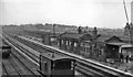
Bulwell Common Station
View southwards, towards Nottingham (Victoria); ex-Great Central 'London Extension' main line, (Annesley) - Nottingham - Leicester (Central) - Marylebone, closed (down to Quainton Road and Aylesbury) 5/9/66. This station was closed on 4/3/63, just four months before the photograph. (There is no trace of the railway there 45 years later).
Image: © Ben Brooksbank
Taken: 12 Jul 1963
0.06 miles
2
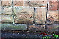
Benchmark on wall post between Nos 306 and 308 St Albans Road
Ordnance Survey cut mark benchmark described on the Bench Mark Database at http://www.bench-marks.org.uk/bm91703
Image: © Roger Templeman
Taken: 28 Nov 2017
0.08 miles
3

Nos. 306 and 304 St Albans Road
There is an OS benchmark Image on the wall pier to the left of the two gateposts
Image: © Roger Templeman
Taken: 28 Nov 2017
0.08 miles
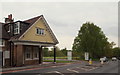
4

Bulwell Common
The trees and houses to the left of the common are on the site of Bulwell Common Station and its associated goods and carriage sidings, built by the Great Central Railway in 1898. The station closed to passengers in 1963 and to all traffic in 1968. It is now hard to imagine there was ever a main line running north through Bulwell.
Image: © John Sutton
Taken: 6 May 2011
0.12 miles
5
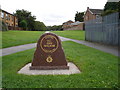
Memorial to PC Ged Walker
Memorial stone to a police officer killed whilst on duty in 2003 [http://news.bbc.co.uk/1/hi/england/nottinghamshire/4286340.stm].
Image: © Oxymoron
Taken: 4 Sep 2008
0.12 miles
6
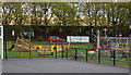
Bestwood NG5, Notts.
A newly revamped children's playground, waiting to be finished off and reopened, is seen here at the eastern edge of Potter's Hollow Recreation Ground at the side of Hucknall Road (the A611). Bulwell Forest Golf Club is situated to the photographer's left, albeit not visible.
Image: © David Hallam-Jones
Taken: 17 May 2013
0.13 miles
7
Bestwood NG5, Notts.
The entrance to Bulwell Forest Municipal Golf Course from Hucknall Road (the A611). The traffic is travelling away from Nottingham, towards Hucknall.
Image: © David Hallam-Jones
Taken: 17 May 2013
0.14 miles
8
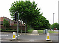
Rigley Drive
Rigley Drive - seen here at the junction with Hucknall Road - takes its name from William Rigley's railway wagon works, which stood to the left of here until the 1960s, specialising in the manufacture and repair of railway wagons and, latterly, the scrapping of steam locomotives. The Great Northern Railway's Leen Valley line, built in 1881 to serve collieries in the Leen valley, ran directly ahead and behind the camera until closure in 1968. Bulwell Forest Station (also behind the camera) closed to passengers as early as 1929.
Image: © John Sutton
Taken: 6 May 2011
0.17 miles
9
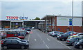
Bestwood NG5, Notts.
It may be the case that Tesco plc. secured planning permission for the construction of this large supermarket following agreement to build this Community Centre that now houses clinic facilities and health worker's offices. These facilities are seen here from a short, elevated path that joins the nearby A611 (Hucknall Road).
Image: © David Hallam-Jones
Taken: 17 May 2013
0.19 miles
10
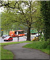
Bestwood NG5, Notts.
Anti-stray golf ball fencing at the side of the Bulwell Forest Municipal Golf Course, on one side of Hucknall Road (the A611). This is the view from a footpath that connects the Top Valley Tesco supermarket - behind the photographer - with the nearest bus stop.
Image: © David Hallam-Jones
Taken: 17 May 2013
0.20 miles