IMAGES TAKEN NEAR TO
Austin Street, NOTTINGHAM, NG6 9HQ
Introduction
This page details the photographs taken nearby to Austin Street, NG6 9HQ by members of the Geograph project.
The Geograph project started in 2005 with the aim of publishing, organising and preserving representative images for every square kilometre of Great Britain, Ireland and the Isle of Man.

There are currently over 7.5m images from over14,400 individuals and you can help contribute to the project by visiting https://www.geograph.org.uk
Image Map (Loading...)


Getting Data...Please wait
Leaflet Map data © OpenStreetMap
Images are licensed for reuse under creativecommons.org/licenses/by-sa/2.0
Notes
- Clicking on the map will re-center to the selected point.
- The higher the marker number, the further away the image location is from the centre of the postcode.
Image Listing (113 Images Found)
Images are licensed for reuse under creativecommons.org/licenses/by-sa/2.0
Image
Details
Distance
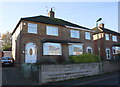
1

Semi detached houses on Warrington Road
Image: © Roger Templeman
Taken: 28 Nov 2017
0.05 miles
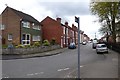
2

Cantrell Road
The black S-Max is emerging from Warrington Road. NCN route 6 also does that.
Image: © David Lally
Taken: 27 Apr 2017
0.10 miles
3
Semi detached houses on Northolme Avenue
Image: © Roger Templeman
Taken: 28 Nov 2017
0.10 miles
4
Austin Street
NCN route 6 runs along here.
Image: © David Lally
Taken: 27 Apr 2017
0.14 miles
5
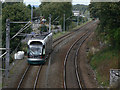
Onwards to Hucknall
A tram leaves Bulwell towards Hucknall. Over this stretch the tram runs on the railway alignment which it shares with the Robin Hood Line (Nottingham - Mansfield - Worksop).
Image: © Alan Murray-Rust
Taken: 27 Aug 2009
0.15 miles
6
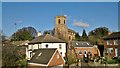
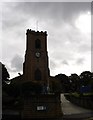
Church of St. Mary the Virgin and All Souls, Bulwell
Image: © Chris Morgan
Taken: 10 Mar 2014
0.16 miles
9
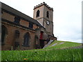
Nottingham - NG6 (Bulwell)
A steep path plus a bridge that allow wheelchair users access to Bulwell Parish Church. Vehicles are compelled to use the steep drive to reach the church car park situated to the right of where the photographer is standing. Wheelchairs then need to be propelled under the bridge, along the side of the church and finally up this steep path in order to reach the side door seen here.
Image: © David Hallam-Jones
Taken: 4 May 2012
0.16 miles
10
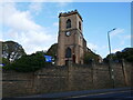
Church of St Mary and All Souls, Bulwell
Buikt in 1849-50 and designed By H I Stevens https://historicengland.org.uk/listing/the-list/list-entry/1254584?section=official-list-entry
Image: © Jonathan Thacker
Taken: 3 Nov 2023
0.17 miles