IMAGES TAKEN NEAR TO
Centurion Business Park, NOTTINGHAM, NG6 8WN
Introduction
This page details the photographs taken nearby to Centurion Business Park, NG6 8WN by members of the Geograph project.
The Geograph project started in 2005 with the aim of publishing, organising and preserving representative images for every square kilometre of Great Britain, Ireland and the Isle of Man.

There are currently over 7.5m images from over14,400 individuals and you can help contribute to the project by visiting https://www.geograph.org.uk
Image Map (Loading...)


Getting Data...Please wait
Leaflet Map data © OpenStreetMap
Images are licensed for reuse under creativecommons.org/licenses/by-sa/2.0
Notes
- Clicking on the map will re-center to the selected point.
- The higher the marker number, the further away the image location is from the centre of the postcode.
Image Listing (8 Images Found)
Images are licensed for reuse under creativecommons.org/licenses/by-sa/2.0
Image
Details
Distance
1
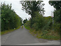
Off Blenheim Lane
The notice points to the small Blenheim Farm caravan campsite.
Image: © Alan Murray-Rust
Taken: 27 Aug 2009
0.18 miles
2
Long Distance footpath
The dark hole to the right of the gate is part of the Robin Hood Way long distance footpath.
Image: © Alan Murray-Rust
Taken: 27 Aug 2009
0.22 miles
3

Blenheim Lane, near Bulwell (1)
This part of Blenheim Lane is basically a farm access road, but it also hosts a public bridleway.
Image: © Richard Vince
Taken: 16 Nov 2013
0.23 miles
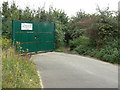
4

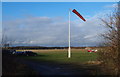
Blenheim Lane and windsock
This is an emergency exit from Watnall Airfield. Blenheim Lane continues on to Bulwellwood Hall Farm.
Image: © Alan Murray-Rust
Taken: 27 Aug 2009
0.23 miles
5
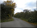
Blenheim Lane, near Bulwell (2)
Looking towards Blenheim Industrial Estate and Bulwell from the Nottingham city boundary.
Image: © Richard Vince
Taken: 16 Nov 2013
0.23 miles
6
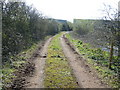
Cart Track
Track round fishing pond, Image, leading to a stable. Blenhiem Industrial Estate can be seen in the back-ground.
Image: © Tony Bacon
Taken: 4 Apr 2007
0.24 miles
7
Nottingham, NG15 - Westville, Hucknall
Halfway along Blenheim Lane - a "No Through Road" - that is off Camberley Road (the A6002) there is a gated emergency entrance/exit in and out of Hucknall Aerodrome, the base of a private flying club and a Rolls Royce components manufacturing site with its main entrance on Watnall Road (the B6009), on the opposite side of the aerodrome. Approximately one third of the way up Blenheim Lane towards Bullwell-Woodhall Farm (sic), i.e behind the photographer, is the boundary separating the Ashfield and Nottingham Council administrative areas. The Robin Hood Way/Trail) between Nottingham and Edwinstowe also uses this stretch of Blenheim Lane.
Image: © David Hallam-Jones
Taken: 15 Dec 2012
0.25 miles
8
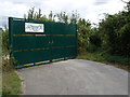
Blenheim New Site Allotments
Most of the northern side of Blenheim Lane is occupied by allotments. This gate marks the western most expansion of the allotments. The footpath marked on the OS map can be seen diving into the bushes on the right of the gates.
Image: © Oxymoron
Taken: 11 Aug 2008
0.25 miles