IMAGES TAKEN NEAR TO
Bestwood Road, NOTTINGHAM, NG6 8UA
Introduction
This page details the photographs taken nearby to Bestwood Road, NG6 8UA by members of the Geograph project.
The Geograph project started in 2005 with the aim of publishing, organising and preserving representative images for every square kilometre of Great Britain, Ireland and the Isle of Man.

There are currently over 7.5m images from over14,400 individuals and you can help contribute to the project by visiting https://www.geograph.org.uk
Image Map
Images are licensed for reuse under creativecommons.org/licenses/by-sa/2.0
Notes
- Clicking on the map will re-center to the selected point.
- The higher the marker number, the further away the image location is from the centre of the postcode.
Image Listing (46 Images Found)
Images are licensed for reuse under creativecommons.org/licenses/by-sa/2.0
Image
Details
Distance
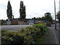
2
Bestwood Road at site of viaduct of dismantled railway
There is an OS benchmark Image on the wall angle (of former railway viaduct) near the right hand side of the image. The London Midland Railway Club Association premises are further along the road
Image: © Roger Templeman
Taken: 28 Nov 2017
0.01 miles
3
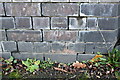
Benchmark on wall of former railway viaduct, Bestwood Road
Ordnance Survey cut mark benchmark described on the Bench Mark Database at http://www.bench-marks.org.uk/bm55738
Image: © Roger Templeman
Taken: 28 Nov 2017
0.03 miles
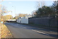
4
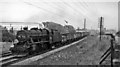
Down empties on Midland (now Robin Hood) line passing under Great Central main line viaduct north of Bulwell
View southward, towards Nottingham; ex-Midland Nottingham - Mansfield - Worksop line - the modern-day Robin Hood Line, running under the ex-Great Central 'London Extension', Sheffield - Nottingham (Victoria)- Marylebone main line - on a substantial viaduct now (2010) long ago demolished. The train is headed by Stanier 8F 2-8-0 No. 48214.
Image: © Ben Brooksbank
Taken: 12 Jul 1963
0.06 miles
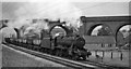
6
Up coal train near Bestwood Colliery Sidings
View northward, towards Mansfield etc.; ex-Midland Nottingham - Mansfield - Worksop line (now the Robin Hood Line). Although it is July, the locomotive (Stanier 8F 2-8-0 No. 48395) is fitted with a snow-plough! The '52' on the front signifies the Trip Number (probably from Kirkby Sidings), but what the chalked 'T95 95' signifies I do not know.
Image: © Ben Brooksbank
Taken: 12 Jul 1963
0.08 miles
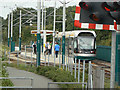
7
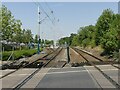
Carey Road level crossing
NET tramway left, with Bulwell Forest stop; Robin Hood Line – railway – to Worksop on the right.
Through Bulwell the tramway occupies the space formerly occupied by the second track of the railway, which was singled to accommodate it.
Image: © Alan Murray-Rust
Taken: 19 Jul 2022
0.08 miles
8
Bestwood Terrace, Bulwell
A side street north of St Albans Road, bounded at its north end by the site of the Great Northern Railway's Leen valley line.
Image: © Richard Vince
Taken: 15 Sep 2012
0.09 miles
9
Bulwell Forest tram stop
This is located just north of Carey Road level crossing.
Image: © Alan Murray-Rust
Taken: 27 Aug 2009
0.09 miles
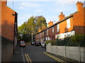
10
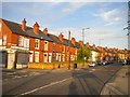
Terraced housing on St Albans Road, Bulwell
The corner shop on the corner of Bestwood Road (left) has become a dental surgery.
Image: © Richard Vince
Taken: 15 Sep 2012
0.11 miles