IMAGES TAKEN NEAR TO
Rhodes Way, Killarney Park, NOTTINGHAM, NG6 8NP
Introduction
This page details the photographs taken nearby to Rhodes Way, Killarney Park, NG6 8NP by members of the Geograph project.
The Geograph project started in 2005 with the aim of publishing, organising and preserving representative images for every square kilometre of Great Britain, Ireland and the Isle of Man.

There are currently over 7.5m images from over14,400 individuals and you can help contribute to the project by visiting https://www.geograph.org.uk
Image Map (Loading...)


Getting Data...Please wait
Leaflet Map data © OpenStreetMap
Images are licensed for reuse under creativecommons.org/licenses/by-sa/2.0
Notes
- Clicking on the map will re-center to the selected point.
- The higher the marker number, the further away the image location is from the centre of the postcode.
Image Listing (24 Images Found)
Images are licensed for reuse under creativecommons.org/licenses/by-sa/2.0
Image
Details
Distance
1
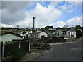
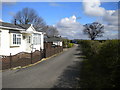
Killarney Park
Settlement of 'mobile homes' with wide views. Walking through here I suddenly felt that I was somewhere on the South Devon Coast!
Image: © Jonathan Thacker
Taken: 31 Mar 2022
0.02 miles
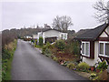
2
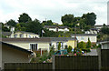
Killarney Park
'Mobile' home development.
Image: © Alan Murray-Rust
Taken: 6 Jul 2010
0.02 miles
3
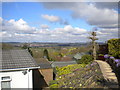
A view across the rooftops, Killarney Park
Looking across the Leen valley towards Hucknall from close to the north end of McClelland Avenue.
Image: © Richard Vince
Taken: 2 Apr 2017
0.04 miles
5
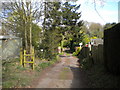
Entering Killarney Park
On a footpath from Goosedale Lane.
Image: © Jonathan Thacker
Taken: 31 Mar 2022
0.04 miles
6
North end of Squires Drive, Killarney Park
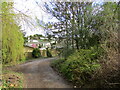
At this point, Squires Drive morphs into a track providing vehicular access to farms. The track also hosts a public footpath that forms part of the Robin Hood Way.
Image: © Richard Vince
Taken: 2 Apr 2017
0.04 miles
7
Squires Drive, Killarney Park
Descending fairly steeply into the Leen valley.
Image: © Richard Vince
Taken: 2 Apr 2017
0.04 miles
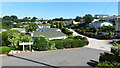
8
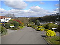
Northern end of McClelland Avenue, Killarney Park
The hilltop situation of Killarney Park becomes suddenly obvious here. In the distance, Hucknall can be seen down in the Leen valley.
Image: © Richard Vince
Taken: 2 Apr 2017
0.05 miles
9
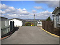
Eastern end of Sunrise Avenue, Killarney Park
Sunrise Avenue forms a cul de sac beyond this point.
Image: © Richard Vince
Taken: 2 Apr 2017
0.06 miles
10
Sunrise Avenue, Killarney Park
The site falls away sharply to the right, leaving these dwellings to catch the rising sun.
Image: © Alan Murray-Rust
Taken: 13 Jan 2008
0.09 miles