IMAGES TAKEN NEAR TO
Second Avenue, Greasley Street, NOTTINGHAM, NG6 8NE
Introduction
This page details the photographs taken nearby to Second Avenue, Greasley Street, NG6 8NE by members of the Geograph project.
The Geograph project started in 2005 with the aim of publishing, organising and preserving representative images for every square kilometre of Great Britain, Ireland and the Isle of Man.

There are currently over 7.5m images from over14,400 individuals and you can help contribute to the project by visiting https://www.geograph.org.uk
Image Map
Images are licensed for reuse under creativecommons.org/licenses/by-sa/2.0
Notes
- Clicking on the map will re-center to the selected point.
- The higher the marker number, the further away the image location is from the centre of the postcode.
Image Listing (21 Images Found)
Images are licensed for reuse under creativecommons.org/licenses/by-sa/2.0
Image
Details
Distance
1
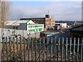
Industrial units on Greasley Road, Bulwell
The green and white building belongs to the Waller Group (building contractors).
Image: © Nikki Mahadevan
Taken: 18 Feb 2007
0.07 miles
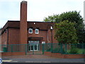
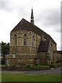
7
The Church of Jesus Christ of Latter-Day Saints, Bulwell
Mormon church in Bulwell.
Image: © Nikki Mahadevan
Taken: 18 Feb 2007
0.21 miles
8
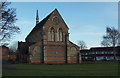
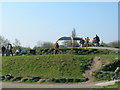
Nottingham, NG6 - Bulwell
Halfway along Rufford Walk - a pedestrian walkway that links the Blenheim area of Bulwell with the 'non town centre end' of Commercial Road - St John's Anglican Church can be found occupying this grassy area, surrounded by a council housing estate. The houses on the right are on Keys Close whilst the two separate Rufford Junior & Infant Schools are situated immediately on the left, albeit off this picture.
Image: © David Hallam-Jones
Taken: 15 Dec 2012
0.22 miles
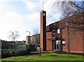
10
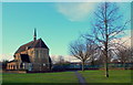
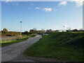
Nottingham, NG6 - Bulwell
Halfway along Rufford Walk - a pedestrian walkway that links the Blenheim area of Bulwell with the 'non town centre end' of Commercial Road - an Anglican Church known as St John the Divine - can be found occupying this grass covered plot surrounded by a council housing estate. Behind the blue-painted fences ahead are the two separate Rufford Junior & Infant Schools.
Image: © David Hallam-Jones
Taken: 15 Dec 2012
0.23 miles