IMAGES TAKEN NEAR TO
Wingbourne Walk, NOTTINGHAM, NG6 8DT
Introduction
This page details the photographs taken nearby to Wingbourne Walk, NG6 8DT by members of the Geograph project.
The Geograph project started in 2005 with the aim of publishing, organising and preserving representative images for every square kilometre of Great Britain, Ireland and the Isle of Man.

There are currently over 7.5m images from over14,400 individuals and you can help contribute to the project by visiting https://www.geograph.org.uk
Image Map
Images are licensed for reuse under creativecommons.org/licenses/by-sa/2.0
Notes
- Clicking on the map will re-center to the selected point.
- The higher the marker number, the further away the image location is from the centre of the postcode.
Image Listing (37 Images Found)
Images are licensed for reuse under creativecommons.org/licenses/by-sa/2.0
Image
Details
Distance
1
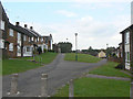
Riseborough Walk and Wingbourne Walk
Built in the style favoured in the 1960s and 70s with the front of the houses facing onto landscaped pedestrian access areas, with vehicle access at the rear.
Image: © Alan Murray-Rust
Taken: 27 Aug 2009
0.06 miles
2
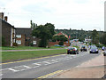
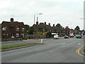
Sandhurst Road
Developed fundamentally as a relatively quiet residential road, in the 1980s it became part of the Nottingham western orbital road, with levels of traffic to match.
Image: © Alan Murray-Rust
Taken: 27 Aug 2009
0.10 miles
3
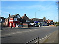
Bulwell - Layton Road Junction with Hucknall Lane (A6002)
Image: © Alan Heardman
Taken: 21 Oct 2007
0.11 miles
4
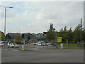
Ken Martin Leisure Centre
Primarily a swimming pool but with other activities. The houses to the left are on the site of the old Bulwell Lido.
Image: © Alan Murray-Rust
Taken: 27 Aug 2009
0.15 miles
5
Hucknall Lane
The houses are part of a large inter-war council housing estate popularly known as Chinatown due to the amount of pottery found there.
Image: © Alan Murray-Rust
Taken: 27 Aug 2009
0.15 miles
6
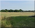
Bulwell Cricket Grounds
Recreating this 'First' for the square https://www.geograph.org.uk/photo/49357 .
The cricket facility appears to have disappeared by about 2011, with play equipment encroaching on what had been the square.
Image: © Alan Murray-Rust
Taken: 19 Jul 2022
0.15 miles
7
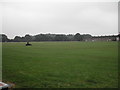
Bulwell Cricket Grounds
It also had a nice Clubhouse until the vandals did their nasty work
Image: © Tom Courtney
Taken: 5 Sep 2005
0.16 miles
9
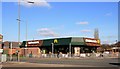
Bulwell's Golden Arches
Hamburger restaurant in the Nottingham suburbs.
Image: © Graham Hogg
Taken: 10 Mar 2014
0.17 miles
10
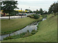
River Leen passing Morrisons
This was once an industrial area, but the most distinctive feature was the magnificent Bulwell Viaduct of the Great Central Railway which crossed the Leen valley just here with 26 arches. http://prints.leics.gov.uk/pictures_671273/bulwell-viaduct-nottinghamshire.html
Image: © Alan Murray-Rust
Taken: 27 Aug 2009
0.17 miles