IMAGES TAKEN NEAR TO
Low Wood Road, NOTTINGHAM, NG6 7GA
Introduction
This page details the photographs taken nearby to Low Wood Road, NG6 7GA by members of the Geograph project.
The Geograph project started in 2005 with the aim of publishing, organising and preserving representative images for every square kilometre of Great Britain, Ireland and the Isle of Man.

There are currently over 7.5m images from over14,400 individuals and you can help contribute to the project by visiting https://www.geograph.org.uk
Image Map
Images are licensed for reuse under creativecommons.org/licenses/by-sa/2.0
Notes
- Clicking on the map will re-center to the selected point.
- The higher the marker number, the further away the image location is from the centre of the postcode.
Image Listing (9 Images Found)
Images are licensed for reuse under creativecommons.org/licenses/by-sa/2.0
Image
Details
Distance

2
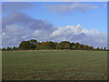
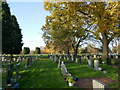
High Wood
This now forms the centre of Nottingham's latest Cemetery.
Image: © Alan Murray-Rust
Taken: 25 Oct 2009
0.08 miles
3
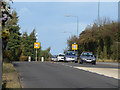
Low Wood Road
This was one of the last sections of the Nottingham outer orbital road to be completed, allowing significant traffic volumes to be routed away from the centre of Bulwell.
Image: © Alan Murray-Rust
Taken: 25 Oct 2009
0.13 miles
4
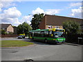
Bus turning at Snape Wood
The bus turning circle at Snape Wood, Bulwell, is unusual in that it does not contain a bus stop. When buses terminated here, they unloaded at a bus stop about 50 metres back along Snape Wood Road, turned in the turning circle and then returned along Snape Wood Road to load at a stop almost opposite their unloading stop. However, buses now serve this area on a circular basis, so buses travel to and from the turning circle in service. This is quite a difficult turning circle in which to photograph buses as it is used for car parking by the residents of the houses adjacent to it.
Image: © Richard Vince
Taken: 11 Jun 2011
0.17 miles
6
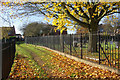
Path to Meadow Rise, Hempshill Vale
This path leads to the estate across Bulwell (Northern) Cemetery, on both sides, although the cemetery itself is well fenced off.
Image: © Stephen McKay
Taken: 11 Nov 2012
0.23 miles
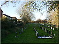
8
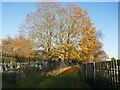
Footpath through the Northern Cemetery, Bulwell
There is no access from the footpath to either section of the cemetery.
Image: © Jonathan Thacker
Taken: 15 Nov 2023
0.24 miles
9
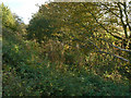
Trains ran here
This was a cutting on the Great Northern Railway line from Nottingham to Derby via Ilkeston. The alignment is now used for the Nuthall Railway Trail, although this follows the top of the cutting side, not the actual trackbed.
Image: © Alan Murray-Rust
Taken: 25 Oct 2009
0.25 miles