IMAGES TAKEN NEAR TO
Cheviot Drive, NOTTINGHAM, NG6 7FH
Introduction
This page details the photographs taken nearby to Cheviot Drive, NG6 7FH by members of the Geograph project.
The Geograph project started in 2005 with the aim of publishing, organising and preserving representative images for every square kilometre of Great Britain, Ireland and the Isle of Man.

There are currently over 7.5m images from over14,400 individuals and you can help contribute to the project by visiting https://www.geograph.org.uk
Image Map (Loading...)


Getting Data...Please wait
Leaflet Map data © OpenStreetMap
Images are licensed for reuse under creativecommons.org/licenses/by-sa/2.0
Notes
- Clicking on the map will re-center to the selected point.
- The higher the marker number, the further away the image location is from the centre of the postcode.
Image Listing (12 Images Found)
Images are licensed for reuse under creativecommons.org/licenses/by-sa/2.0
Image
Details
Distance
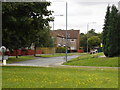
2
Snape Wood Road
Part of the large areas of council residential development to the west of Bulwell in the 1960s to 1980s.
Image: © Alan Murray-Rust
Taken: 27 Aug 2009
0.08 miles
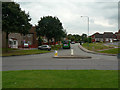
3
Seller's Wood Drive
The final section into Snape Wood estate.
Image: © Alan Murray-Rust
Taken: 19 Jul 2022
0.12 miles
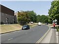
4
Bennerley Road
The way into Blenheim Industrial Estate. Buses only run a small number of journeys each day to suit main working hours.
Image: © Alan Murray-Rust
Taken: 27 Aug 2009
0.15 miles
5
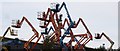
Blenheim Industrial Estate: Hi-loaders
The shape of these hi-loaders against the sky is as good as a modern sculpture.
Image: © Oxymoron
Taken: 11 Aug 2008
0.20 miles
6
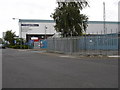
Blenheim Industrial Estate
The Co-op food distribution centre on Freeston Drive
Image: © Oxymoron
Taken: 11 Aug 2008
0.23 miles
7
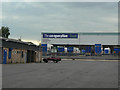
The Co-operative food
This is a large regional distribution centre on Blenheim Industrial Estate.
Image: © Alan Murray-Rust
Taken: 27 Aug 2009
0.23 miles
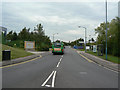
8
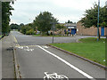
Bennerley Road
Part of the Blenheim Industrial Estate, developed on the site of former quarries. The cycle and pedestrian link in the foreground connects with Blenheim Lane.
Image: © Alan Murray-Rust
Taken: 27 Aug 2009
0.23 miles
10
The Limekiln
Pub serving the Snape Wood area.
Image: © Alan Murray-Rust
Taken: 19 Jul 2022
0.23 miles