IMAGES TAKEN NEAR TO
Mariner Court, NOTTINGHAM, NG6 7BW
Introduction
This page details the photographs taken nearby to Mariner Court, NG6 7BW by members of the Geograph project.
The Geograph project started in 2005 with the aim of publishing, organising and preserving representative images for every square kilometre of Great Britain, Ireland and the Isle of Man.

There are currently over 7.5m images from over14,400 individuals and you can help contribute to the project by visiting https://www.geograph.org.uk
Image Map
Images are licensed for reuse under creativecommons.org/licenses/by-sa/2.0
Notes
- Clicking on the map will re-center to the selected point.
- The higher the marker number, the further away the image location is from the centre of the postcode.
Image Listing (20 Images Found)
Images are licensed for reuse under creativecommons.org/licenses/by-sa/2.0
Image
Details
Distance
2
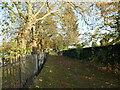
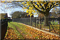
Footpath through the Northern Cemetery, Bulwell
There is no access from the footpath to either section of the cemetery.
Image: © Jonathan Thacker
Taken: 15 Nov 2023
0.09 miles
3
Footpath through the Northern Cemetery, Bulwell
There is no access from the footpath to either section of the cemetery.
Image: © Jonathan Thacker
Taken: 15 Nov 2023
0.09 miles
4
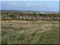
Tip top view of Hempshill Vale
The nearest housing is Hempshill Vale, a privately developed estate which was in many respects an extension to the council's Crabtree Estate. The distant industry is Hucknall airfield, part of which is occupied by Rolls Royce. In the distance the hills around Annesley which include the highest point in Nottinghamshire.
Image: © Alan Murray-Rust
Taken: 25 Oct 2009
0.10 miles
5
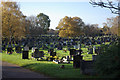
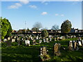
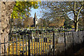
Bulwell (Northern) Cemetery
This cemetery, first opened for burials in 1903, covers 30 acres.
Image: © Stephen McKay
Taken: 11 Nov 2012
0.12 miles
6
Footpath through the Northern Cemetery, Bulwell
There is no access from the footpath to either section of the cemetery.
Image: © Jonathan Thacker
Taken: 15 Nov 2023
0.13 miles
7
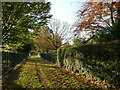
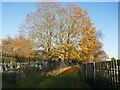
Path to Meadow Rise, Hempshill Vale
This path leads to the estate across Bulwell (Northern) Cemetery, on both sides, although the cemetery itself is well fenced off.
Image: © Stephen McKay
Taken: 11 Nov 2012
0.14 miles
9
Bulwell (Northern) Cemetery
Looking towards the chapel at the heart of this cemetery that first opened for burials in 1903. The cemetery covers 30 acres.
Image: © Stephen McKay
Taken: 11 Nov 2012
0.15 miles
10
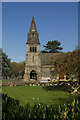
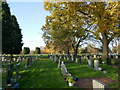
Bulwell (Northern) Cemetery
This vast cemetery, covering 30 acres, was opened in 1903. The chapel, seen here, holds 60 people.
Image: © Stephen McKay
Taken: 11 Nov 2012
0.15 miles