
IMAGES TAKEN NEAR TO
Wicker Close, NOTTINGHAM, NG6 0FQ
Introduction
This page details the photographs taken nearby to Wicker Close, NG6 0FQ by members of the Geograph project.
The Geograph project started in 2005 with the aim of publishing, organising and preserving representative images for every square kilometre of Great Britain, Ireland and the Isle of Man.

There are currently over 7.5m images from over14,400 individuals and you can help contribute to the project by visiting https://www.geograph.org.uk
Image Map
Images are licensed for reuse under creativecommons.org/licenses/by-sa/2.0
Notes
- Clicking on the map will re-center to the selected point.
- The higher the marker number, the further away the image location is from the centre of the postcode.
Image Listing (55 Images Found)
Images are licensed for reuse under creativecommons.org/licenses/by-sa/2.0
Image
Details
Distance
1
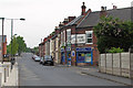
Park Lane
For a close-up of the old Home Brewery sign on the off licence on the corner of Cheltenham Street, see Image Straight ahead Park Lane once crossed the Great Northern Railway line from Nottingham to Derby Friargate. The bridge is still there, but there is little other evidence there was ever a railway here as the railway land has been redeveloped for housing and commercial purposes. See Image], Image] and Image
Image: © John Sutton
Taken: 6 May 2011
0.03 miles
2
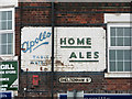
Apollo Table Waters and Home Ales
Old Basford is a good place for old painted signs on former Home Brewery Company off licences. This example, on the corner of Park Lane and Cheltenham Street, is the traditional version, advertising Apollo fizzy drinks and the Daybrook brew; on nearby Arnold Road the beer-off sports the 1960s version - see Image
Image: © John Sutton
Taken: 6 May 2011
0.04 miles
3
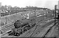
A V2 2-6-2 approaching Basford North station from Nottingham Victoria
View eastward on the ex-Great Northern lines, towards Daybrook and Colwick ahead under the bridge carrying the ex-Great Central main line from Nottingham Victoria to Sheffield; Basford North (former Basford & Bulwell) station is behind the camera. The locomotive is Gresley V2 2-6-2 No. 60878 on the loop towards Bagthorpe Junction and Nottingham Victoria.
Image: © Ben Brooksbank
Taken: 28 Mar 1956
0.05 miles
4

The site of Basford North Station
This view westwards from the former railway bridge on Park Lane shows the industrial units built on what was from 1878-1968 Basford North railway station, on the Great Northern Railway line from Nottingham to Derby Friargate, a line built principally to carry coal from Erewash Valley pits to the marshalling yard at Colwick for onward despatch. Ben Brooksbank's Image] shows the station from the west, looking towards here, in the days of steam.
Image: © John Sutton
Taken: 6 May 2011
0.05 miles
5

Great Northern Railway bridge, Park Lane, Basford
The trackbed of the Great Northern line to Derby has been partly filled in to make a small playground. The curious-looking parapet was a British Railways replacement for the wrought-iron original and rather remarkably dates from 1965 - a year after passenger services ceased and only two years before the line was abandoned completely. Basford North station was to the left and the Basford East junctions, leading to where the GNR met the Great Central main line, the southbound line via the "Rathole" tunnel, were to the right. The other side of this bridge appears, under the footbridge, in Ben Brooksbank's 1963 pictures Image] and Image My father always called this "Dobby Bridge", but I've no idea why, or if anyone else did, or of the name's origin.
Image: © John Sutton
Taken: 25 Aug 2010
0.07 miles
6

East from Park Lane bridge
This view eastwards from Park Lane bridge shows how the course of the former Great Northern Railway line from Nottingham to Derby Friargate has been obliterated since it closed in 1968. Ben Brooksbank's Image] shows what the lines east of here looked like in the days of steam; the position of the engine in that picture was just beyond the houses straight ahead.
Image: © John Sutton
Taken: 6 May 2011
0.08 miles
7
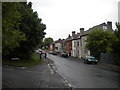
Park Lane, Basford
Looking north from the south eastern end of Brooklyn Road.
Image: © Richard Vince
Taken: 11 Jun 2013
0.09 miles
8
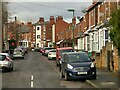
Wallis Street, Basford
Classic turn of the century (c.1900) Nottingham with 2 and 3 storey red brick terraced houses.
Image: © Alan Murray-Rust
Taken: 22 Feb 2022
0.10 miles
9
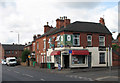
Basford: Arnold Road off-licence
To Nottinghamians an off-licence is a beer-off. On this one the Home Brewery style of the 1960s, with Robin Hood silhouette on a barrel-shaped background, rather remarkably survives intact. The earlier style, on pubs and off-licences http://www.geograph.org.uk/photo/1513926 , simply featured the words Home Ales, in green or black on a cream background. Sometimes the brewery's Apollo mineral waters ("pop") were also advertised - see the off-licence on Park Lane nearby: Image
Image: © John Sutton
Taken: 25 Aug 2010
0.13 miles
10
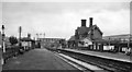
Basford North (former Basford & Bulwell) Station
View eastward, towards Nottingham (Victoria), Colwick etc. and Grantham. Basford & Bulwell station only became 'Basford North' on 21/9/53; it was closed on 7/9/64 to passengers, along with the service from Derby (Friargate) etc. (goods 4/9/67). Beyond the station can be seen Park Lane Bridge, beyond which was the bridge carrying the main ex-Great Central line from Sheffield (Victoria) to Nottingham and the South. Trains through this station to/from Nottingham Victoria joined the main line at Bagthorpe Junction by connections either side of this bridge. A curve to the left just beyond the end of the Up (left) platform connected at Bulwell South Junction with the main line towards Sheffield. The lines straight ahead led to Leen Valley Junction and by the Daybrook Loop ('Back Line') round the north side of Nottingham to the great Colwick Yards and the main line to Grantham; the Back Line lost its meagre passenger services after the partial collapse of Mapperley Tunnel on 4/4/60, although Goods continued until 1/6/64. The GC main line effectively ceased as a through route on 5/9/66 and Nottingham Victoria closed on 5/7/67.
Image: © Ben Brooksbank
Taken: 21 Aug 1963
0.13 miles