IMAGES TAKEN NEAR TO
Wilton Street, NOTTINGHAM, NG6 0ER

Introduction

This page details the photographs taken nearby to Wilton Street, NG6 0ER by members of the Geograph project.

The Geograph project started in 2005 with the aim of publishing, organising and preserving representative images for every square kilometre of Great Britain, Ireland and the Isle of Man.

There are currently over 7.5m images from over14,400 individuals and you can help contribute to the project by visiting https://www.geograph.org.uk

Image Map


Images are licensed for reuse under creativecommons.org/licenses/by-sa/2.0
Notes
  • Clicking on the map will re-center to the selected point.
  • The higher the marker number, the further away the image location is from the centre of the postcode.

Image Listing (52 Images Found)

Images are licensed for reuse under creativecommons.org/licenses/by-sa/2.0
  • ...
Image
Details
Distance
1
Wallis Street, Basford
Classic turn of the century (c.1900) Nottingham with 2 and 3 storey red brick terraced houses.
Image: © Alan Murray-Rust Taken: 22 Feb 2022
0.05 miles
2
Park Lane
For a close-up of the old Home Brewery sign on the off licence on the corner of Cheltenham Street, see Image Straight ahead Park Lane once crossed the Great Northern Railway line from Nottingham to Derby Friargate. The bridge is still there, but there is little other evidence there was ever a railway here as the railway land has been redeveloped for housing and commercial purposes. See Image], Image] and Image
Image: © John Sutton Taken: 6 May 2011
0.05 miles
3
Basford: Arnold Road off-licence
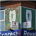
To Nottinghamians an off-licence is a beer-off. On this one the Home Brewery style of the 1960s, with Robin Hood silhouette on a barrel-shaped background, rather remarkably survives intact. The earlier style, on pubs and off-licences http://www.geograph.org.uk/photo/1513926 , simply featured the words Home Ales, in green or black on a cream background. Sometimes the brewery's Apollo mineral waters ("pop") were also advertised - see the off-licence on Park Lane nearby: Image
Image: © John Sutton Taken: 25 Aug 2010
0.06 miles
4
Home Ales ghost sign
Still just surviving. Last visited by me seven years ago Image With the oldest picture on the site being by John Sutton Image
Image: © David Lally Taken: 17 Jul 2021
0.06 miles
5
Braai Flavours and Home Ales, Arnold Road
The painted panels are a relic of the days of the Home Brewery, closed in 1999. The shop was formerly an off-licence. (There is a second sign on the Wilton Street side, behind the new panel).
Image: © Alan Murray-Rust Taken: 22 Feb 2022
0.07 miles
6
Sibu Fish and Meat
Their See Food signs now cover an old Home Ales sign which was uncovered the last time I visited Image
Image: © David Lally Taken: 10 Jul 2024
0.07 miles
7
Apollo Table Waters and Home Ales
Old Basford is a good place for old painted signs on former Home Brewery Company off licences. This example, on the corner of Park Lane and Cheltenham Street, is the traditional version, advertising Apollo fizzy drinks and the Daybrook brew; on nearby Arnold Road the beer-off sports the 1960s version - see Image
Image: © John Sutton Taken: 6 May 2011
0.07 miles
8
Home Ales Sign
See Image for context.
Image: © David Lally Taken: 23 Mar 2014
0.07 miles
9
Royal Express convenience store
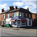
On the corner of Arnold Road and Wallace Street, Basford. The Home Ales sign is a bit more worse-for-wear than when John Sutton was here 3 and a half years ago http://www.geograph.org.uk/photo/2037260 . And is now further obscured by the MoneyGram signs. Closer view: Image
Image: © David Lally Taken: 23 Mar 2014
0.07 miles
10
A V2 2-6-2 approaching Basford North station from Nottingham Victoria
View eastward on the ex-Great Northern lines, towards Daybrook and Colwick ahead under the bridge carrying the ex-Great Central main line from Nottingham Victoria to Sheffield; Basford North (former Basford & Bulwell) station is behind the camera. The locomotive is Gresley V2 2-6-2 No. 60878 on the loop towards Bagthorpe Junction and Nottingham Victoria.
Image: © Ben Brooksbank Taken: 28 Mar 1956
0.09 miles
  • ...