IMAGES TAKEN NEAR TO
Chiltern Close, NOTTINGHAM, NG5 9PX
Introduction
This page details the photographs taken nearby to Chiltern Close, NG5 9PX by members of the Geograph project.
The Geograph project started in 2005 with the aim of publishing, organising and preserving representative images for every square kilometre of Great Britain, Ireland and the Isle of Man.

There are currently over 7.5m images from over14,400 individuals and you can help contribute to the project by visiting https://www.geograph.org.uk
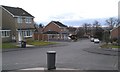
Image Map
Images are licensed for reuse under creativecommons.org/licenses/by-sa/2.0
Notes
- Clicking on the map will re-center to the selected point.
- The higher the marker number, the further away the image location is from the centre of the postcode.
Image Listing (71 Images Found)
Images are licensed for reuse under creativecommons.org/licenses/by-sa/2.0
Image
Details
Distance
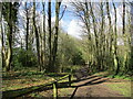
3

Footpath in Bestwood Country Park
Once on the southern edge of the Royal hunting forest of Sherwood, Bestwood Forest was a favourite sporting venue for Medieval, Tudor and Stuart Royalty when in Nottingham. It is now a country park and extends to the reclaimed colliery site at Bestwood Village.
Image: © Kate Jewell
Taken: 26 May 2009
0.04 miles
4
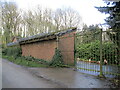
Maintenance yard, Bestwood Country Park
Image: © Jonathan Thacker
Taken: 31 Mar 2022
0.06 miles
5
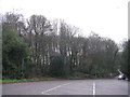
Woodland in winter
Part of the Bestwood Country park seen from the car park of the Bestwood Lodge Hotel.
Image: © M J Richardson
Taken: 2 Jan 2016
0.08 miles
6
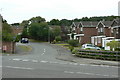
Grampian Drive
Off Bewcastle Road; it leads to a group of roads with names of British mountain ranges.
Image: © Alan Murray-Rust
Taken: 20 Jul 2010
0.10 miles
7
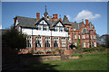
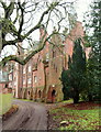
Bestwood Lodge Hotel
By S.S.Teulon 1862-65 for the 10th Duke of St Albans, after a post-war spell with the MOD it became a hotel http://www.bestwoodlodgehotel.co.uk/ in the 1970s
Image: © Richard Croft
Taken: 20 Apr 2010
0.10 miles
8
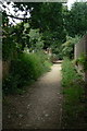
Footpath near Bestwood Lodge
Leading to Sidlaw Drive
Image: © Alan Murray-Rust
Taken: 20 Jul 2010
0.10 miles
9
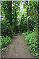
Footpath through the park
Just west of Bestwood Lodge is an area of mature mixed woodland. A mixture of footpaths and bridleways give extensive public access.
Image: © Kate Jewell
Taken: 26 May 2009
0.11 miles
10
Bestwood Lodge, Bestwood, NG5, Notts
The service road and northern elevation of this former hunting lodge.
Image: © David Hallam-Jones
Taken: 21 Nov 2014
0.11 miles