IMAGES TAKEN NEAR TO
Shellburne Close, NOTTINGHAM, NG5 9LL
Introduction
This page details the photographs taken nearby to Shellburne Close, NG5 9LL by members of the Geograph project.
The Geograph project started in 2005 with the aim of publishing, organising and preserving representative images for every square kilometre of Great Britain, Ireland and the Isle of Man.

There are currently over 7.5m images from over14,400 individuals and you can help contribute to the project by visiting https://www.geograph.org.uk
Image Map
Images are licensed for reuse under creativecommons.org/licenses/by-sa/2.0
Notes
- Clicking on the map will re-center to the selected point.
- The higher the marker number, the further away the image location is from the centre of the postcode.
Image Listing (10 Images Found)
Images are licensed for reuse under creativecommons.org/licenses/by-sa/2.0
Image
Details
Distance
1
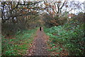
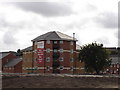
Footpath through woodland strip on east side of A611
Image: © Roger Templeman
Taken: 28 Nov 2017
0.14 miles
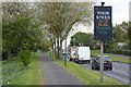
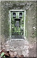
2

Pavement and woodland strip beside Hucknall Road (A611)
Ordnance Survey documents indicate that a benchmark levelled at 70.881m above Newlyn Datum was verified in 1979 on a braced concrete post at the side of the road here
Image: © Roger Templeman
Taken: 28 Nov 2017
0.15 miles
3
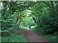
Footpath on the former Leen Valley Railway
The Great Northern Railway's Leen Valley line, built in 1881 to serve collieries in the Leen valley (and extended through Sutton in Ashfield to Langwith in 1898), ran directly ahead and behind the camera until closure in 1968. The Leen Valley line lost its regular passenger service as early as 1929.
Image: © John Sutton
Taken: 6 May 2011
0.21 miles
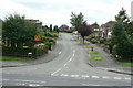
4
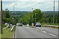
Bestwood Park Drive West
Looking down the hill towards Bulwell. Note how tree growth has reduced the visual impact of urban development since this 1986 view http://www.geograph.org.uk/photo/2004889 .
Image: © Alan Murray-Rust
Taken: 20 Jul 2010
0.23 miles
5
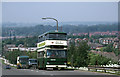
Bestwood Park Drive West
Looking down the hill towards Bulwell. Compare how the trees have grown in the 25 years since this image http://www.geograph.org.uk/photo/2004885 was taken
Image: © Alan Murray-Rust
Taken: 14 Jun 1986
0.23 miles
7
Speed indicator on Bestwood Park Drive West
Image: © David Lally
Taken: 27 Apr 2017
0.23 miles
8
Langbank Avenue
This marks the southern limit of the original Rise Park development, readily discernable on maps. See the description on this image http://www.geograph.org.uk/photo/2004844
Image: © Alan Murray-Rust
Taken: 20 Jul 2010
0.23 miles
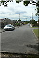
9
Rise Park Road
The western junction with Bestwood Park Drive West.
Image: © Alan Murray-Rust
Taken: 20 Jul 2010
0.24 miles
10
Benchmark on Bulwell Forest Golf Course triangulation pillar
Ordnance Survey flush bracket (serial identifier S4617) benchmark described on the Bench Mark Database at http://www.bench-marks.org.uk/bm6070
Image: © Roger Templeman
Taken: 28 Nov 2017
0.25 miles