IMAGES TAKEN NEAR TO
Burrows Way, NG5 8RW
Introduction
This page details the photographs taken nearby to Burrows Way, NG5 8RW by members of the Geograph project.
The Geograph project started in 2005 with the aim of publishing, organising and preserving representative images for every square kilometre of Great Britain, Ireland and the Isle of Man.

There are currently over 7.5m images from over14,400 individuals and you can help contribute to the project by visiting https://www.geograph.org.uk
Image Map
Images are licensed for reuse under creativecommons.org/licenses/by-sa/2.0
Notes
- Clicking on the map will re-center to the selected point.
- The higher the marker number, the further away the image location is from the centre of the postcode.
Image Listing (59 Images Found)
Images are licensed for reuse under creativecommons.org/licenses/by-sa/2.0
Image
Details
Distance
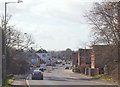
1
Redhill, NG5, Notts.
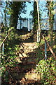
With Redhill behind them, pedestrians walking uphill along the side of the A60 (i.e. the Nottingham-Mansfield Road) may notice this set of redundant steps. In bygone days they provided workers on foot, coming from Redhill, easier access to the former industrial site at the top of the steps. The main (gated) entrance to this now levelled "Works" site is situated a minute's walk further uphill. The final residential street in Redhill, i.e. Lodge Close, is situated 100 yds downhill, to the left of this picture.
Image: © David Hallam-Jones
Taken: 16 Feb 2014
0.03 miles
2
Redhill Works
Now merely a pile of rubble.
Image: © Alan Murray-Rust
Taken: 6 Jul 2010
0.03 miles
3
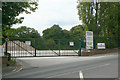
Redhill, NG5 Notts.
The main entrance to a former industrial site off the A60 (the Mansfield-Nottingham Road). This levelled site is situated on the approach into Redhill from the Mansfield/Ollerton direction. The first residential street in Redhill, i.e. Lodge Close, is situated on the right just past this entrance. The Ram Inn, a prominent local landmark (built in 1789) is visible ahead, on the left.
Image: © David Hallam-Jones
Taken: 16 Feb 2014
0.04 miles
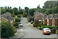
4
Lodge Close
Cul-de-sac off the A60 Mansfield Road at Redhill.
Image: © Alan Murray-Rust
Taken: 6 Jul 2010
0.04 miles
5
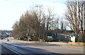
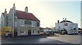
Redhill, NG5, Notts.
This is the view of Redhill that motorists first see having descended the A60 from the Mansfield direction, i.e. down Arch Hill, with Lodge Close, the first residential street on the right immediately beyond the wind-battered wooden fence. On the left are two well-established pubs, The Waggon & Horses - nearest to the camera - and The Ram Inn. An old farm house at the foot of Red Hill is said to have been a post house where horses could be changed and guides hired by travellers for the journey through Sherwood Forest on the London-York route. Later on it became a coaching inn named The Waggon & Horses.
Image: © David Hallam-Jones
Taken: 16 Feb 2014
0.06 miles
6
Georgia Drive, near Lodge Farm Lane
Part of the Lodge Farm estate of the 1980s.
Image: © Alan Murray-Rust
Taken: 6 Jul 2010
0.08 miles
7
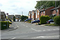
Redhill, NG5, Notts.
This private drive off the ascending Nottingham-Mansfield Road provides one means of access to a small cluster of private houses situated on the west side of the road bridge ahead, that carries traffic over the A60.
Image: © David Hallam-Jones
Taken: 16 Feb 2014
0.10 miles
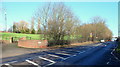
8
Looking across the A60
Springtime afternoon by the Mansfield Road.
Image: © Andrew Hill
Taken: 17 Apr 2010
0.10 miles
9
Redhill, NG5, Notts.
The Waggon & Horses - nearest to the camera - dates from 1827, whilst The Ram Inn is thought to have been established in 1789. It seems that The Waggon and Horses started life as a farm house at the foot of Red Hill, where it is said horses could be changed and guides hired by travellers for the journey through Sherwood Forest on the London-York route. Later on it became a coaching inn. A footpath linking the main road with Lodge Farm Lane behind The Ram Inn runs along the side of "The Ram" behind the more distant telegraph pole.
Image: © David Hallam-Jones
Taken: 16 Feb 2014
0.10 miles
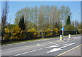
10
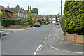
Lodge Farm Road
Developed from a farm lane into housing in the 1980s.
Image: © Alan Murray-Rust
Taken: 6 Jul 2010
0.10 miles