IMAGES TAKEN NEAR TO
Howbeck Road, NOTTINGHAM, NG5 8QA
Introduction
This page details the photographs taken nearby to Howbeck Road, NG5 8QA by members of the Geograph project.
The Geograph project started in 2005 with the aim of publishing, organising and preserving representative images for every square kilometre of Great Britain, Ireland and the Isle of Man.

There are currently over 7.5m images from over14,400 individuals and you can help contribute to the project by visiting https://www.geograph.org.uk
Image Map
Images are licensed for reuse under creativecommons.org/licenses/by-sa/2.0
Notes
- Clicking on the map will re-center to the selected point.
- The higher the marker number, the further away the image location is from the centre of the postcode.
Image Listing (10 Images Found)
Images are licensed for reuse under creativecommons.org/licenses/by-sa/2.0
Image
Details
Distance
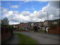
1
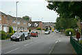
Howbeck Road
This section of the road marked the end of housing development for around 20 years before the development of Gleneagles Drive.
Image: © Alan Murray-Rust
Taken: 18 Jan 2009
0.11 miles
2
Gleneagles Drive
Part of the later stages of the housing development in the area, completed in the early 1980s.
Image: © Alan Murray-Rust
Taken: 6 Jul 2010
0.17 miles
3
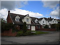
Houses on Cromdale Close, Killisick
At the bottom of one of several cul de sacs of this part of Howbeck Road.
Image: © Richard Vince
Taken: 12 May 2014
0.17 miles
4
Howbeck Road, Killisick
Looking towards Hamilton Close.
Image: © Richard Vince
Taken: 12 May 2014
0.19 miles
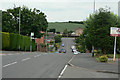
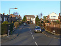
5
Killisick Road
Looking south from the bus terminus.
Image: © Alan Murray-Rust
Taken: 6 Jul 2010
0.22 miles
6
Mapperley Orchard
1960s development off Coppice Road.
Image: © Alan Murray-Rust
Taken: 18 Jan 2009
0.23 miles
7
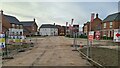
Alexandra Place, Mapperley
The start of a big development of over 160 new homes
Image: © Chris Morgan
Taken: 8 Nov 2021
0.23 miles
8
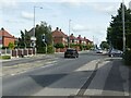
Coppice Road at Howbeck Road
Coppice Road was originally Spout Lane, before housing was developed in the area. Mapping from just before WW2 shows that there was a small development just around this cross-roads, clearly intended as the basis of later development, but delayed by the war. The style of housing is typical of local council estates.
Image: © Alan Murray-Rust
Taken: 12 Aug 2021
0.24 miles
9
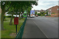
Killisick Road
With the local postbox Killisick Lane (ref. NG5 507) and bus terminus.
Image: © Alan Murray-Rust
Taken: 6 Jul 2010
0.24 miles
10
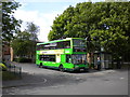
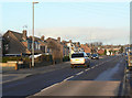
Bus at Killisick terminus
A 59 to Nottingham city centre stands at the exit from the large bus turning circle at Killisick. This is also the terminus for the 58, so it is often a very busy place.
Image: © Richard Vince
Taken: 21 May 2011
0.25 miles