IMAGES TAKEN NEAR TO
Thornton Avenue, NOTTINGHAM, NG5 8PA
Introduction
This page details the photographs taken nearby to Thornton Avenue, NG5 8PA by members of the Geograph project.
The Geograph project started in 2005 with the aim of publishing, organising and preserving representative images for every square kilometre of Great Britain, Ireland and the Isle of Man.

There are currently over 7.5m images from over14,400 individuals and you can help contribute to the project by visiting https://www.geograph.org.uk
Image Map
Images are licensed for reuse under creativecommons.org/licenses/by-sa/2.0
Notes
- Clicking on the map will re-center to the selected point.
- The higher the marker number, the further away the image location is from the centre of the postcode.
Image Listing (36 Images Found)
Images are licensed for reuse under creativecommons.org/licenses/by-sa/2.0
Image
Details
Distance
1
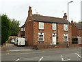
321 Mansfield Road, Redhill, Nottingham
Early 19th century house with rear wing housing traditional framework knitters workshop. Listed Grade II.
Image: © Alan Murray-Rust
Taken: 21 Aug 2019
0.07 miles
2

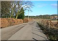
Redhill, NG5, Notts.
A footpath running parallel with the rear gardens of houses on Richmond Gardens (on the left). This particular spot is a few hundred metres from the A60 (the main Nottingham-Mansfield Road) and is part of a public footpath that links Harberton Close and the western edge of Bestwood Country Park.
Image: © David Hallam-Jones
Taken: 16 Feb 2014
0.09 miles
3
Redhill, NG5, Notts.
The commencement of (or termination of) a public footpath leading to/from Bestwood Country Park 20 minutes away westwards. This entrance/exit is off Harberton Close. Harberton Close is off Henry Street.
Image: © David Hallam-Jones
Taken: 16 Feb 2014
0.09 miles
4
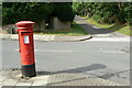
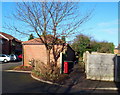
Redhill Lodge Drive postbox ref: NG5 474
Standard EIIR pillar box, distinctly out of vertical.
Image: © Alan Murray-Rust
Taken: 20 Jul 2010
0.10 miles
7
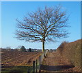
New Farm vicinity, Redhill NG5, Notts.
The public footpath that links Harberton Close, Redhill and the western edge of Bestwood Country Park is seen here at one of its highest points.
Image: © David Hallam-Jones
Taken: 16 Feb 2014
0.12 miles
10

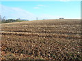
Redhill, NG5, Notts.
This part of the Harberton Close-Bestwood Country Park public footpath shows it leaving the 'more enclosed' stretch that runs at the rear of houses on Richmond Gardens and Henry Street and coming out into farmland.
Image: © David Hallam-Jones
Taken: 16 Feb 2014
0.12 miles