IMAGES TAKEN NEAR TO
Robin Hood Road, NOTTINGHAM, NG5 8NP
Introduction
This page details the photographs taken nearby to Robin Hood Road, NG5 8NP by members of the Geograph project.
The Geograph project started in 2005 with the aim of publishing, organising and preserving representative images for every square kilometre of Great Britain, Ireland and the Isle of Man.

There are currently over 7.5m images from over14,400 individuals and you can help contribute to the project by visiting https://www.geograph.org.uk
Image Map
Images are licensed for reuse under creativecommons.org/licenses/by-sa/2.0
Notes
- Clicking on the map will re-center to the selected point.
- The higher the marker number, the further away the image location is from the centre of the postcode.
Image Listing (52 Images Found)
Images are licensed for reuse under creativecommons.org/licenses/by-sa/2.0
Image
Details
Distance
1
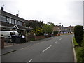
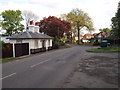
Robin Hood Road, Bestwood Park
A residential cul de sac close to the northern edge of Bestwood Park estate.
Image: © Richard Vince
Taken: 11 Jun 2013
0.06 miles
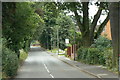
2
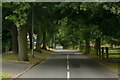
Woodchurch Road
Originally an avenue leading to Emmanuel Church, from which the name presumably derives.
Image: © Alan Murray-Rust
Taken: 20 Jul 2010
0.07 miles
3
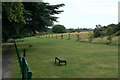
Along Woodchurch Road
Recreational open space. This was originally attached to the Bestwood Lodge parkland and included a cricket ground further to the right.
Image: © Alan Murray-Rust
Taken: 20 Jul 2010
0.09 miles
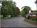
4
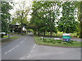
Nottingham - NG5 (Bestwood)
Woodchurch Road on the left is a continuation of Bestwood Lodge Drive and a cul-de-sac. The road branching off to the right leading to Bestwood Lodge Hotel, Bestwood Country Park and the Fire Service Headquarters peters out here and becomes a minor access road.
Image: © David Hallam-Jones
Taken: 16 May 2012
0.09 miles
5
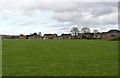
Recreation ground, Robin Hood Road
This is formally part of Bestwood Country Park.
Image: © Alan Murray-Rust
Taken: 18 Mar 2014
0.09 miles
6
Nottingham - NG5 (Bestwood)
Presumably "The Old Lodge" on Bestwood Lodge Drive, was "as it says on the tin", a lodge at this entrance/exit to the main estate. In 1650 the main Hall - Bestwood Lodge - was "set in an enclosed park of about 3,000 acres of which 100 acres were tilled and the rest left in pasture". Woodchurch Road on the left is a "No Through Road".
Image: © David Hallam-Jones
Taken: 16 May 2012
0.10 miles
7
Bestwood Lodge Drive
Once just what the name implies, but now giving access to quite a lot of housing development.
Image: © Alan Murray-Rust
Taken: 20 Jul 2010
0.10 miles
8
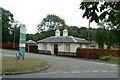
The Old Lodge
The eastern lodge to Bestwood Lodge. It predates the main house itself, dating from around 1820. Listed Grade II.
Image: © Alan Murray-Rust
Taken: 20 Jul 2010
0.10 miles
9
Nottingham - NG5 (Bestwood)
"The Old Lodge" at the side of the drive leading to The Bestwood Lodge Hotel, Bestwood Country Park and the Fire Service Headquarters is a private residence. This photograph was taken looking in the direction of the Bestwood Park Estate and Oxclose Lane (B6004). Behind the former lodge arable farmland is to be found situated in the Gedling Borough Council administrative jurisdiction.
Image: © David Hallam-Jones
Taken: 16 May 2012
0.10 miles
10
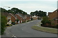
Deer Park Drive
1990s housing development off Bestwood Lodge Drive.
Image: © Alan Murray-Rust
Taken: 20 Jul 2010
0.11 miles