IMAGES TAKEN NEAR TO
The Mount, NOTTINGHAM, NG5 8LU
Introduction
This page details the photographs taken nearby to The Mount, NG5 8LU by members of the Geograph project.
The Geograph project started in 2005 with the aim of publishing, organising and preserving representative images for every square kilometre of Great Britain, Ireland and the Isle of Man.

There are currently over 7.5m images from over14,400 individuals and you can help contribute to the project by visiting https://www.geograph.org.uk
Image Map
Images are licensed for reuse under creativecommons.org/licenses/by-sa/2.0
Notes
- Clicking on the map will re-center to the selected point.
- The higher the marker number, the further away the image location is from the centre of the postcode.
Image Listing (21 Images Found)
Images are licensed for reuse under creativecommons.org/licenses/by-sa/2.0
Image
Details
Distance
1
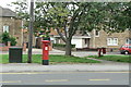
Mansfield Road postbox ref: NG5 415
Standard EIIR pillar box. The name is not particularly helpful as Mansfield Road is several miles long and has a number of postboxes.
Image: © Alan Murray-Rust
Taken: 20 Jul 2010
0.08 miles
2
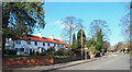
Redhill, NG5, Notts.
Some C19th(?) cottages opposite Monsell Drive on the A60, the main Nottingham to Mansfield road. This is the stretch of the road 2-3 minutes walk north of Redhill Cemetery looking towards the Ram Inn (a local landmark), in the Mansfield direction.
Image: © David Hallam-Jones
Taken: 7 Mar 2014
0.08 miles
3
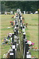
Gravestones, Redhill Cemetery
Many of these are having to be supported by straps to prevent them falling over.
Image: © Alan Murray-Rust
Taken: 20 Jul 2010
0.08 miles
4
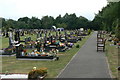
Redhill Cemetery
Pathway at the northern end of the cemetery.
Image: © Alan Murray-Rust
Taken: 20 Jul 2010
0.09 miles
5
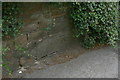
Bench mark, Mansfield Road
A piece of hard stone has been specifically built into the wall for this bench mark as the local sandstone of which the rest of the wall is constructed is soft and weathers easily.
Image: © Alan Murray-Rust
Taken: 20 Jul 2010
0.11 miles
6
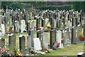
Redhill Cemetery
View of the northern section.
Image: © Alan Murray-Rust
Taken: 20 Jul 2010
0.12 miles
8
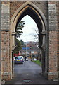
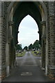
Redhill, NG5, Notts.
The A60, i.e. the main Nottingham-Mansfield road is visible through an archway created by the twin mortuary chapels, one of each of these chapels on either side of a roadway through this construction. Arnold Cemetery was set aside for this purpose in 1877 and originally covered a four acre site. The first burial here was conducted in July 1879. It is still in regular use although various extension plots have been added behind the photographer's left shoulder. Full capacity, it seems, may be achieved within the next 10 years. Meanwhile, the local authority is giving serious consideration to building the 'first ever' crematorium within the city boundary, near to the Travellers' Rest pub, Mapperley Plain.
Image: © David Hallam-Jones
Taken: 7 Mar 2014
0.12 miles
9
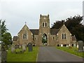
Redhill Cemetery mortuary chapels
Classic paired chapels with central carriageway, late 19th century. It is not clear whether the tower ever carried a spire.
Image: © Alan Murray-Rust
Taken: 21 Aug 2019
0.12 miles
10
Redhill Cemetery
View along the drive through the chapel of rest.
Image: © Alan Murray-Rust
Taken: 20 Jul 2010
0.13 miles