IMAGES TAKEN NEAR TO
Georgia Drive, NOTTINGHAM, NG5 8HX
Introduction
This page details the photographs taken nearby to Georgia Drive, NG5 8HX by members of the Geograph project.
The Geograph project started in 2005 with the aim of publishing, organising and preserving representative images for every square kilometre of Great Britain, Ireland and the Isle of Man.

There are currently over 7.5m images from over14,400 individuals and you can help contribute to the project by visiting https://www.geograph.org.uk
Image Map
Images are licensed for reuse under creativecommons.org/licenses/by-sa/2.0
Notes
- Clicking on the map will re-center to the selected point.
- The higher the marker number, the further away the image location is from the centre of the postcode.
Image Listing (44 Images Found)
Images are licensed for reuse under creativecommons.org/licenses/by-sa/2.0
Image
Details
Distance
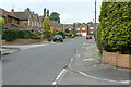
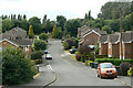
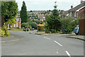
1
Georgia Drive, Arnold
A residential street at the edge of the main built up area.
Image: © Andrew Hill
Taken: 17 Apr 2010
0.02 miles
2
Lodge Farm Road
Developed from a farm lane into housing in the 1980s.
Image: © Alan Murray-Rust
Taken: 6 Jul 2010
0.04 miles
3
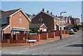
Houldsworth Rise, Arnold
A residential street, the "Rise" being an appropriate name in this instance.
Image: © Andrew Hill
Taken: 17 Apr 2010
0.05 miles
4
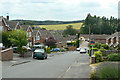
Houldsworth Rise
Part of the Lodge Farm estate of the 1980s.
Image: © Alan Murray-Rust
Taken: 6 Jul 2010
0.07 miles
5
Georgia Drive, near Lodge Farm Lane
Part of the Lodge Farm estate of the 1980s.
Image: © Alan Murray-Rust
Taken: 6 Jul 2010
0.07 miles
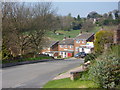
6
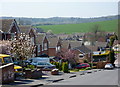
Looking down Houldsworth Rise
The main road into Nottingham crosses between houses at the lowest point. The height allows open countryside beyond to be seen.
Image: © Andrew Hill
Taken: 17 Apr 2010
0.07 miles
7
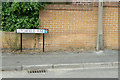
Bench mark at Litchfield Rise
A relatively modern mark, cut into a retaining wall.
Image: © Alan Murray-Rust
Taken: 6 Jul 2010
0.09 miles
8
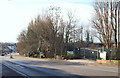
Redhill, NG5 Notts.
The main entrance to a former industrial site off the A60 (the Mansfield-Nottingham Road). This levelled site is situated on the approach into Redhill from the Mansfield/Ollerton direction. The first residential street in Redhill, i.e. Lodge Close, is situated on the right just past this entrance. The Ram Inn, a prominent local landmark (built in 1789) is visible ahead, on the left.
Image: © David Hallam-Jones
Taken: 16 Feb 2014
0.11 miles
9
Pentwood Avenue
Part of the Lodge Farm estate of the 1980s.
Image: © Alan Murray-Rust
Taken: 6 Jul 2010
0.11 miles
10
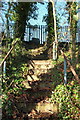
Redhill, NG5, Notts.
With Redhill behind them, pedestrians walking uphill along the side of the A60 (i.e. the Nottingham-Mansfield Road) may notice this set of redundant steps. In bygone days they provided workers on foot, coming from Redhill, easier access to the former industrial site at the top of the steps. The main (gated) entrance to this now levelled "Works" site is situated a minute's walk further uphill. The final residential street in Redhill, i.e. Lodge Close, is situated 100 yds downhill, to the left of this picture.
Image: © David Hallam-Jones
Taken: 16 Feb 2014
0.11 miles