IMAGES TAKEN NEAR TO
Redhill Road, NOTTINGHAM, NG5 8GT
Introduction
This page details the photographs taken nearby to Redhill Road, NG5 8GT by members of the Geograph project.
The Geograph project started in 2005 with the aim of publishing, organising and preserving representative images for every square kilometre of Great Britain, Ireland and the Isle of Man.

There are currently over 7.5m images from over14,400 individuals and you can help contribute to the project by visiting https://www.geograph.org.uk
Image Map
Images are licensed for reuse under creativecommons.org/licenses/by-sa/2.0
Notes
- Clicking on the map will re-center to the selected point.
- The higher the marker number, the further away the image location is from the centre of the postcode.
Image Listing (56 Images Found)
Images are licensed for reuse under creativecommons.org/licenses/by-sa/2.0
Image
Details
Distance
1
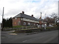
Elevated houses on Church Street, Arnold
Accessed via a service road that climbs more sharply than Church Street itself for some reason. The bottom of Mellors Road can just be seen on the left.
Image: © Richard Vince
Taken: 22 Mar 2014
0.07 miles
2
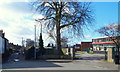
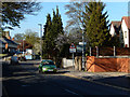
Redhill, NG5, Notts.
Redhill Road turns to the left here in front of the entrance into Cherry Close (an unadopted cul-de-sac). Redhill Academy, formerly Redhill Comprehensive School, is seen on the right.
Image: © David Hallam-Jones
Taken: 16 Feb 2014
0.07 miles
3
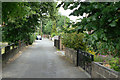
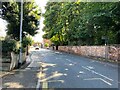
Allen's Walk
An old established footpath which although being developed with housing, has managed to avoid becoming a vehicle thoroughfare.
Image: © Alan Murray-Rust
Taken: 6 Jul 2010
0.08 miles
4
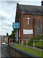
Church for sale
The former Cross Street Baptist Church.
Image: © Alan Murray-Rust
Taken: 12 Aug 2021
0.08 miles
5
Church Street, Arnold
Just to the north of Arnold centre, Church Street leads up to St Mary's Church.
Image: © Stephen McKay
Taken: 18 Apr 2015
0.09 miles
7
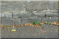
Bench mark on Church Road
It took me a little time to spot this as the level of the footway has clearly been raised over the years. Being so close to the foot, and in the typical soft sandstone of the area means that it has become severely eroded.
Image: © Alan Murray-Rust
Taken: 6 Jul 2010
0.09 miles
8
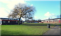
Redhill, NG5, Notts.
A classroom block at Redhill Academy, formerly Redhill Comprehensive School, and part of Arnold Leisure Centre on the left are seen here from Cherry Close.
Image: © David Hallam-Jones
Taken: 16 Feb 2014
0.09 miles
10
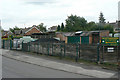
Scattergoods
Traditional coal merchant, still operating on Church Street, Arnold.
Image: © Alan Murray-Rust
Taken: 6 Jul 2010
0.10 miles