IMAGES TAKEN NEAR TO
Surgeys Lane, NOTTINGHAM, NG5 8FX
Introduction
This page details the photographs taken nearby to Surgeys Lane, NG5 8FX by members of the Geograph project.
The Geograph project started in 2005 with the aim of publishing, organising and preserving representative images for every square kilometre of Great Britain, Ireland and the Isle of Man.

There are currently over 7.5m images from over14,400 individuals and you can help contribute to the project by visiting https://www.geograph.org.uk
Image Map
Images are licensed for reuse under creativecommons.org/licenses/by-sa/2.0
Notes
- Clicking on the map will re-center to the selected point.
- The higher the marker number, the further away the image location is from the centre of the postcode.
Image Listing (29 Images Found)
Images are licensed for reuse under creativecommons.org/licenses/by-sa/2.0
Image
Details
Distance
1
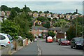
Jenned Road
Looking down to the junction with Surgeys Lane.
Image: © Alan Murray-Rust
Taken: 6 Jul 2010
0.05 miles
2

Surgey's Lane (Road and Bridleway)
Image: © Jonathan Clitheroe
Taken: 9 Sep 2024
0.05 miles
3
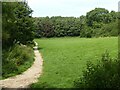
Footpath off Surgeys Lane
The area has been retained as local open space.
Image: © Alan Murray-Rust
Taken: 12 Aug 2021
0.07 miles
4
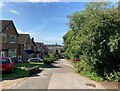
Surgey's Lane (Road and Bridleway)
Image: © Jonathan Clitheroe
Taken: 9 Sep 2024
0.08 miles
5
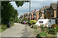
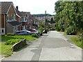
Top of Surgeys Lane
Despite the modern housing, this section of the lane still shows its heritage as a rural bridleway.
Image: © Alan Murray-Rust
Taken: 6 Jul 2010
0.09 miles
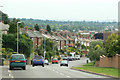
6
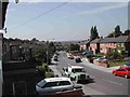
Surgeys Lane, Arnold, Nott's
Taken from one of the bedroom windows of my own home, I feel it shows a true picture of this square
Image: © Tom Courtney
Taken: 18 Aug 2004
0.10 miles
7
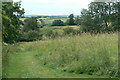
Field near Surgeys Lane
This appears to have become open space, as it is access by a number of formal pedestrian entrances to several paths, most of which are not formal rights of way.
Image: © Alan Murray-Rust
Taken: 6 Jul 2010
0.10 miles
8
The top of Surgeys Lane
1970s housing along what was a traditional country lane.
Image: © Alan Murray-Rust
Taken: 12 Aug 2021
0.10 miles
10
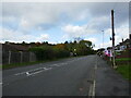
Calverton Road
Looking down towards Arnold. The road is climbing up to the high point of Dorket Head. The extensive view takes in Ratcliffe Power Station, 19 kilometres distant
Image: © Alan Murray-Rust
Taken: 6 Jul 2010
0.11 miles