IMAGES TAKEN NEAR TO
Calverton Road, NOTTINGHAM, NG5 8FR
Introduction
This page details the photographs taken nearby to Calverton Road, NG5 8FR by members of the Geograph project.
The Geograph project started in 2005 with the aim of publishing, organising and preserving representative images for every square kilometre of Great Britain, Ireland and the Isle of Man.

There are currently over 7.5m images from over14,400 individuals and you can help contribute to the project by visiting https://www.geograph.org.uk
Image Map
Images are licensed for reuse under creativecommons.org/licenses/by-sa/2.0
Notes
- Clicking on the map will re-center to the selected point.
- The higher the marker number, the further away the image location is from the centre of the postcode.
Image Listing (20 Images Found)
Images are licensed for reuse under creativecommons.org/licenses/by-sa/2.0
Image
Details
Distance
2
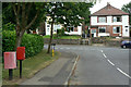
Sutton Road postbox - ref. NG5 416
Standard EIIR lamp box serving modern housing development.
Image: © Alan Murray-Rust
Taken: 6 Jul 2010
0.03 miles
3
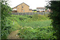
Calverton Road Storage Area
The notice on the gate originally refers to Gedling Borough Council but has been overlaid by Severn Trent Water stickers. This is clearly a storm water catchment pond to prevent flooding in times of heavy rainfall.
Image: © Alan Murray-Rust
Taken: 6 Jul 2010
0.04 miles
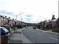
5
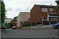
Sutton Road
1970s housing development off Calverton Road
Image: © Alan Murray-Rust
Taken: 6 Jul 2010
0.09 miles
6
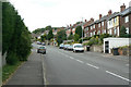
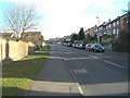
Calverton Road
Looking uphill near Ashington Drive.
Image: © Alan Murray-Rust
Taken: 6 Jul 2010
0.10 miles
7
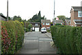
Footpath to Victoria Close
1970s housing development off Calverton Road
Image: © Alan Murray-Rust
Taken: 6 Jul 2010
0.10 miles
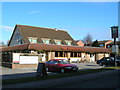
8
Surgeys Road
Part of the extensiv housing development to the north of Arnold from the 1950s. This is one of the main bus routes into the area.
Image: © Alan Murray-Rust
Taken: 6 Jul 2010
0.15 miles
9
Surgeys Lane, Arnold, Notts
Recreating this 'First' for the square http://www.geograph.org.uk/photo/34094 . The precise location, as indicated by the description of the original view, was naturally not accessible!
Image: © Alan Murray-Rust
Taken: 12 Aug 2021
0.15 miles
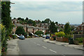
10
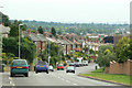
Calverton Road
Looking down towards Arnold. The road is climbing up to the high point of Dorket Head. The extensive view takes in Ratcliffe Power Station, 19 kilometres distant
Image: © Alan Murray-Rust
Taken: 6 Jul 2010
0.16 miles