IMAGES TAKEN NEAR TO
Willbert Road, NOTTINGHAM, NG5 8ED
Introduction
This page details the photographs taken nearby to Willbert Road, NG5 8ED by members of the Geograph project.
The Geograph project started in 2005 with the aim of publishing, organising and preserving representative images for every square kilometre of Great Britain, Ireland and the Isle of Man.

There are currently over 7.5m images from over14,400 individuals and you can help contribute to the project by visiting https://www.geograph.org.uk
Image Map
Images are licensed for reuse under creativecommons.org/licenses/by-sa/2.0
Notes
- Clicking on the map will re-center to the selected point.
- The higher the marker number, the further away the image location is from the centre of the postcode.
Image Listing (14 Images Found)
Images are licensed for reuse under creativecommons.org/licenses/by-sa/2.0
Image
Details
Distance
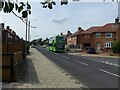
1
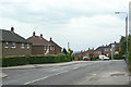
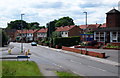
Birchfield Road at Hawthorn Crescent
This is part of the main bus route through the estates to the north and north-east of Arnold.
Image: © Alan Murray-Rust
Taken: 6 Jul 2010
0.10 miles
4
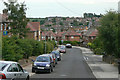
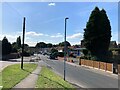
Hawthorn Crescent
Part of the extensive housing development of the 1950s to the north of Arnold.
Image: © Alan Murray-Rust
Taken: 6 Jul 2010
0.13 miles
5
Lime line service 58 on Birchfield Road
Service 58 is the principal service from Nottingham to the Arnold area, running at least every 10 minutes Monday to Saturday daytime. Seen here is one of Nottingham City Transport's large fleet of biogas-powered buses.
Image: © Alan Murray-Rust
Taken: 12 Aug 2021
0.18 miles
6
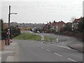
Junction, Calverton Road and Surgeys Lane, Arnold. 2004
Taken in 2004 this is the first of two photos to show how places change in the course of almost 80 years. Where the road sign is on the left, once stood an old church. This has now been replaced with a brick built one, set further back from the road
Image: © Tom Courtney
Taken: 12 Apr 2004
0.22 miles
7
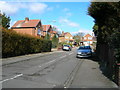
Beechwood Road, Arnold
This road leads from Coppice Rd on to the Killisick Estate. The estate church is the odd building at the top of the road.
Image: © Tom Courtney
Taken: 9 Aug 2005
0.22 miles
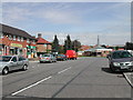
8
Beechwood Road, Arnold
Recreating this 'First' for the square http://www.geograph.org.uk/photo/35574 .
This was the main bus terminus in the area when I first came to Nottingham in the late 70s, but became redundant as a bus route following the development of the Killisick housing estate. Now the only bus service is the night service N58 which operates Friday and Saturday nights only.
Image: © Alan Murray-Rust
Taken: 12 Aug 2021
0.22 miles
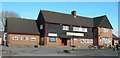
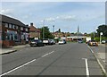
9
Arnold, Notts
A section of Calverton Road near to the point at which it becomes Church Street and continues in the direction of Arnold's town centre. Arnold United Reformed Church on the right is a church that began life as a Congregational Chapel in 1871 but changed its title in 1972 when three quarters of English Congregational churches merged with the English branch of the Presbyterian Church to form the United Reformed Church (URC). On the left is the junction with Surgey's Lane. The Surgey family has existed in Arnold since 1797. The surname seems likely to have arisen from the occupational name for a person who performed operations, mostly amputations, deriving from the Middle English and Old French term 'sur(ri)gien'. Before anaesthetics were invented only primitive surgery was possible and this was often carried out by a barber or attendant. Variant forms of the name include Surge(o)ner, Surgenor and Surgen and the first recorded use of it is thought to be that of William le Suriegien, in 1273, in the Hundred Rolls of Northamptonshire produced in the reign of King Edward 1.
Image: © David Hallam-Jones
Taken: 12 Jul 2012
0.23 miles
10
Calverton Road in Arnold
The blue-doored building on the right is Arnold United Reformed Church.
Image: © Jonathan Clitheroe
Taken: 9 Sep 2024
0.23 miles