IMAGES TAKEN NEAR TO
Cedar Grove, NOTTINGHAM, NG5 8BZ
Introduction
This page details the photographs taken nearby to Cedar Grove, NG5 8BZ by members of the Geograph project.
The Geograph project started in 2005 with the aim of publishing, organising and preserving representative images for every square kilometre of Great Britain, Ireland and the Isle of Man.

There are currently over 7.5m images from over14,400 individuals and you can help contribute to the project by visiting https://www.geograph.org.uk
Image Map
Images are licensed for reuse under creativecommons.org/licenses/by-sa/2.0
Notes
- Clicking on the map will re-center to the selected point.
- The higher the marker number, the further away the image location is from the centre of the postcode.
Image Listing (16 Images Found)
Images are licensed for reuse under creativecommons.org/licenses/by-sa/2.0
Image
Details
Distance
1
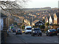
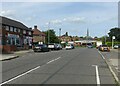
Coppice Road
This drops down off Mapperley Plains towards the centre of Arnold. The hilly nature of this area is well evident. The road is an old thoroughfare predating the developments from the 1950s onwards.
Image: © Alan Murray-Rust
Taken: 18 Jan 2009
0.13 miles
2
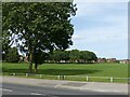
Killisick Recreation Ground
Seen from Coppice Road.
Image: © Alan Murray-Rust
Taken: 12 Aug 2021
0.14 miles
3
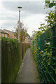
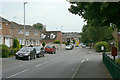
Urban footpath
Linking Pinewood Avenue with Kilbourne Road.
Image: © Alan Murray-Rust
Taken: 6 Jul 2010
0.15 miles
4
Beechwood Road, Arnold
This road leads from Coppice Rd on to the Killisick Estate. The estate church is the odd building at the top of the road.
Image: © Tom Courtney
Taken: 9 Aug 2005
0.15 miles
5
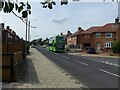
Beechwood Road, Arnold
Recreating this 'First' for the square http://www.geograph.org.uk/photo/35574 .
This was the main bus terminus in the area when I first came to Nottingham in the late 70s, but became redundant as a bus route following the development of the Killisick housing estate. Now the only bus service is the night service N58 which operates Friday and Saturday nights only.
Image: © Alan Murray-Rust
Taken: 12 Aug 2021
0.15 miles
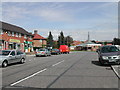
6
Killisick Road
Looking south from the bus terminus.
Image: © Alan Murray-Rust
Taken: 6 Jul 2010
0.16 miles
7
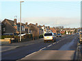
Lime line service 58 on Birchfield Road
Service 58 is the principal service from Nottingham to the Arnold area, running at least every 10 minutes Monday to Saturday daytime. Seen here is one of Nottingham City Transport's large fleet of biogas-powered buses.
Image: © Alan Murray-Rust
Taken: 12 Aug 2021
0.16 miles
8
Howbeck Road
This section of the road marked the end of housing development for around 20 years before the development of Gleneagles Drive.
Image: © Alan Murray-Rust
Taken: 18 Jan 2009
0.19 miles
9
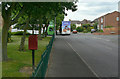
Killisick Road
With the local postbox Killisick Lane (ref. NG5 507) and bus terminus.
Image: © Alan Murray-Rust
Taken: 6 Jul 2010
0.19 miles
10
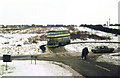
The new Killisick terminus
The large housing development off Killisick Lane was yet to start, but the bus terminus was already in place. Contrast this with the modern view, with developed housing and mature trees. http://www.geograph.org.uk/photo/1952780
This is one of a series of views featuring buses in the 60s, 70s, and 80s. http://www.geograph.org.uk/search.php?i=2114547&displayclass=slide
Image: © Alan Murray-Rust
Taken: 16 Feb 1979
0.19 miles