IMAGES TAKEN NEAR TO
Kilbourne Road, NOTTINGHAM, NG5 8AT
Introduction
This page details the photographs taken nearby to Kilbourne Road, NG5 8AT by members of the Geograph project.
The Geograph project started in 2005 with the aim of publishing, organising and preserving representative images for every square kilometre of Great Britain, Ireland and the Isle of Man.

There are currently over 7.5m images from over14,400 individuals and you can help contribute to the project by visiting https://www.geograph.org.uk
Image Map
Images are licensed for reuse under creativecommons.org/licenses/by-sa/2.0
Notes
- Clicking on the map will re-center to the selected point.
- The higher the marker number, the further away the image location is from the centre of the postcode.
Image Listing (16 Images Found)
Images are licensed for reuse under creativecommons.org/licenses/by-sa/2.0
Image
Details
Distance
1
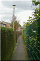
Urban footpath
Linking Pinewood Avenue with Kilbourne Road.
Image: © Alan Murray-Rust
Taken: 6 Jul 2010
0.07 miles
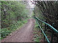
2
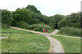
Footpath junction
The undeveloped area between Killisick Lane, Homefield Avenue and Kilbourne Road has been turned into open space with a network of footpaths. None of these follow the line of the right of way shown on the Ordnance Survey maps.
Image: © Alan Murray-Rust
Taken: 6 Jul 2010
0.09 miles
3
Killisick bus terminus
Taken for comparison with how it looked when the bus turnround was first constructed http://www.geograph.org.uk/photo/1952773.
Image: © Alan Murray-Rust
Taken: 6 Jul 2010
0.09 miles
4
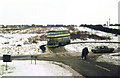
The new Killisick terminus
The large housing development off Killisick Lane was yet to start, but the bus terminus was already in place. Contrast this with the modern view, with developed housing and mature trees. http://www.geograph.org.uk/photo/1952780
This is one of a series of views featuring buses in the 60s, 70s, and 80s. http://www.geograph.org.uk/search.php?i=2114547&displayclass=slide
Image: © Alan Murray-Rust
Taken: 16 Feb 1979
0.10 miles
5
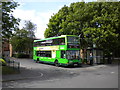
Bus at Killisick terminus
A 59 to Nottingham city centre stands at the exit from the large bus turning circle at Killisick. This is also the terminus for the 58, so it is often a very busy place.
Image: © Richard Vince
Taken: 21 May 2011
0.10 miles
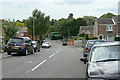
6
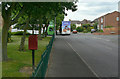
Killisick Road
With the local postbox Killisick Lane (ref. NG5 507) and bus terminus.
Image: © Alan Murray-Rust
Taken: 6 Jul 2010
0.11 miles
7
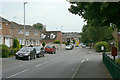
Killisick Road
Looking south from the bus terminus.
Image: © Alan Murray-Rust
Taken: 6 Jul 2010
0.12 miles
8
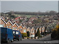
North from Patricia Drive, Arnold
The line of trees hide an old clay pit at Dorket Head, which is now a landfill site ( in other words they dump rubbish there). From where the photo was taken, many years ago was a windmill, but all there is now are houses and roads
Image: © Tom Courtney
Taken: 12 Apr 2004
0.15 miles
9
Killisick Lane, Arnold
this bridleway runs from the top of Surgeys Lane, (Which used to be called Broadass Lane ), to The Killisick Housing estate
Image: © Tom Courtney
Taken: 15 Apr 2004
0.15 miles
10
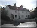
The White Cottage, Surgeys Lane Arnold
Actually at one time three cottages and the first dwellings on Surgeys Lane, though when they were built over 150 years ago the lane was known as Broadass Lane
Image: © Tom Courtney
Taken: 19 Feb 2004
0.15 miles