IMAGES TAKEN NEAR TO
Ellesmere Close, NOTTINGHAM, NG5 7NB
Introduction
This page details the photographs taken nearby to Ellesmere Close, NG5 7NB by members of the Geograph project.
The Geograph project started in 2005 with the aim of publishing, organising and preserving representative images for every square kilometre of Great Britain, Ireland and the Isle of Man.

There are currently over 7.5m images from over14,400 individuals and you can help contribute to the project by visiting https://www.geograph.org.uk
Image Map
Images are licensed for reuse under creativecommons.org/licenses/by-sa/2.0
Notes
- Clicking on the map will re-center to the selected point.
- The higher the marker number, the further away the image location is from the centre of the postcode.
Image Listing (15 Images Found)
Images are licensed for reuse under creativecommons.org/licenses/by-sa/2.0
Image
Details
Distance
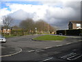
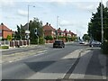
1
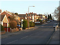
Coppice Road
The final steep section up to the ridge of Mapperley Plains.
Image: © Alan Murray-Rust
Taken: 18 Jan 2009
0.01 miles
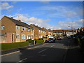
2
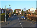
Mapperley Orchard
1960s development off Coppice Road.
Image: © Alan Murray-Rust
Taken: 18 Jan 2009
0.06 miles
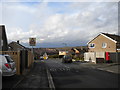
5
Bus turning circle, Newcombe Drive, Plains Estate
This turning circle, at the end of Newcombe Drive and sort of built into its junction with Darlton Drive (foreground), was largely unused for several years, the main bus service through Plains Estate continuing along Ramsey Drive and then via Coppice Road to Arnold (rather than serving Newcombe Drive). However, nine days after this photograph was taken, Nottingham City Transport introduced route 57, which serves Newcombe Drive half hourly during the day, and terminates here. Hopefully the car on the extreme left is no longer parked there.
Image: © Richard Vince
Taken: 22 Mar 2014
0.16 miles
7
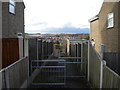
Public footpath to Langford Road, Plains Estate
This footpath links Darlton Drive, in Plains Estate (and on the pavement of which the photographer is standing), with Langford Road, which is in an area of council housing off Rolleston Drive on the eastern edge of Arnold.
Image: © Richard Vince
Taken: 22 Mar 2014
0.18 miles
8
Newcombe Drive, Plains Estate
Newcombe Drive is named after John Newcombe, an Australian tennis player who won twelve Grand Slam men's doubles titles in the 1960s and 1970s. His partner for all twelve was Tony Roche, after whom Image is named. The view is from the end of Davidson Close; I'm afraid I don't know after which Davidson it is named.
Image: © Richard Vince
Taken: 22 Mar 2014
0.20 miles
9
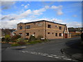
The King's Centre, Shirley Drive, Arnold
The premises of The King's Church, Arnold, occupied by them since 2002.
Image: © Richard Vince
Taken: 22 Mar 2014
0.20 miles
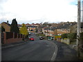
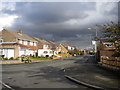
10
Coppice Road at Howbeck Road
Coppice Road was originally Spout Lane, before housing was developed in the area. Mapping from just before WW2 shows that there was a small development just around this cross-roads, clearly intended as the basis of later development, but delayed by the war. The style of housing is typical of local council estates.
Image: © Alan Murray-Rust
Taken: 12 Aug 2021
0.21 miles