IMAGES TAKEN NEAR TO
Ramsey Drive, NOTTINGHAM, NG5 6QL
Introduction
This page details the photographs taken nearby to Ramsey Drive, NG5 6QL by members of the Geograph project.
The Geograph project started in 2005 with the aim of publishing, organising and preserving representative images for every square kilometre of Great Britain, Ireland and the Isle of Man.

There are currently over 7.5m images from over14,400 individuals and you can help contribute to the project by visiting https://www.geograph.org.uk
Image Map (Loading...)


Getting Data...Please wait
Leaflet Map data © OpenStreetMap
Images are licensed for reuse under creativecommons.org/licenses/by-sa/2.0
Notes
- Clicking on the map will re-center to the selected point.
- The higher the marker number, the further away the image location is from the centre of the postcode.
Image Listing (11 Images Found)
Images are licensed for reuse under creativecommons.org/licenses/by-sa/2.0
Image
Details
Distance
1
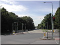
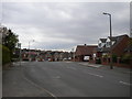
Arnovale Road, Arnold
the junction of Gedling Road and Arnovale Road in Arnold, Nottinghamshire
Image: © Tom Courtney
Taken: 9 Aug 2005
0.07 miles
2
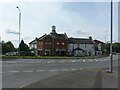
The Arrow, Gedling Road
Large suburban pub, built at the time of the major development of housing in the area in the 1960s and 70s.
Image: © Alan Murray-Rust
Taken: 12 Aug 2021
0.08 miles
3
Arno Vale Road, Arnold
Recreating this 'First' for the square http://www.geograph.org.uk/photo/35576
Image: © Alan Murray-Rust
Taken: 12 Aug 2021
0.09 miles
4
Footballers Estate
The roads in the area are named after members of the England team which won the 1966 Football World Cup
Image: © Alan Murray-Rust
Taken: 1 Feb 2009
0.14 miles
5
Site of Arno Vale bus turning circle (2)
The house with the pair of dormer windows (right) was built on the site of the turning circle provided for Nottingham City Transport bus route 10, which terminated here. It was rendered redundant when the Arnold area services were reorganised around 1980, with the Arno Vale service being extended to Plains Estate and Arnold (much as today's routes 56 and 57 serve this area now). After being fenced off but still visible for many years, the site was developed for a small quantity of housing a few years ago.
Image: © Richard Vince
Taken: 17 Apr 2014
0.16 miles
6
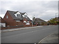
Site of Arno Vale bus turning circle (1)
The house with the pair of dormer windows was built on the site of the turning circle provided for Nottingham City Transport bus route 10, which terminated here. It was rendered redundant when the Arnold area services were reorganised around 1980, with the Arno Vale service being extended to Plains Estate and Arnold (much as today's routes 56 and 57 serve this area now). After being fenced off but still visible for many years, the site was developed for a small quantity of housing a few years ago.
Image: © Richard Vince
Taken: 17 Apr 2014
0.16 miles
7
Open space
This area was safeguarded when the area was redeveloped in the late 1960s for the extension of Arno Vale Road up to Mapperley Plains to replace the relatively narrow Gedling Road. With the proposals to develop the former Gedling Colliery site, this could be resurrected.
Image: © Alan Murray-Rust
Taken: 1 Feb 2009
0.16 miles
8
East end of Walsingham Road, Arno Vale
Image: © Richard Vince
Taken: 17 Apr 2014
0.18 miles
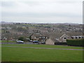
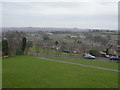
9
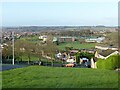
Green way through the housing
The open space was earmarked for the extension of Arno Vale Road which would line up with the new Gedling Access Road. A final decision has been made to leave it as open space. The view also shows the brand new Arnold Hill Academy building; compare with this 2013 view from more or less the same viewpoint https://www.geograph.org.uk/photo/3463819 .
Image: © Alan Murray-Rust
Taken: 22 Nov 2020
0.19 miles
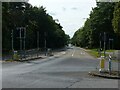
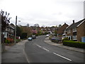
10
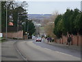
Gedling Road
The main road out of Arnold to Gedling climbing up to the Mapperley ridge.
Image: © Alan Murray-Rust
Taken: 1 Feb 2009
0.21 miles