IMAGES TAKEN NEAR TO
Downham Close, NOTTINGHAM, NG5 6PR
Introduction
This page details the photographs taken nearby to Downham Close, NG5 6PR by members of the Geograph project.
The Geograph project started in 2005 with the aim of publishing, organising and preserving representative images for every square kilometre of Great Britain, Ireland and the Isle of Man.

There are currently over 7.5m images from over14,400 individuals and you can help contribute to the project by visiting https://www.geograph.org.uk
Image Map
Images are licensed for reuse under creativecommons.org/licenses/by-sa/2.0
Notes
- Clicking on the map will re-center to the selected point.
- The higher the marker number, the further away the image location is from the centre of the postcode.
Image Listing (5 Images Found)
Images are licensed for reuse under creativecommons.org/licenses/by-sa/2.0
Image
Details
Distance
1
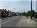
Gedling Road, Arnold
Part of the historic road network, with housing developed in the post-WW2 period.
Image: © Alan Murray-Rust
Taken: 12 Aug 2021
0.14 miles
2
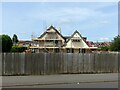
Removing the render
Sunnyhome is the last remaining house in the immediate locality which survives from before the development of Arno Vale Road and the housing visible in the background in the second half of the 20th century.
Image: © Alan Murray-Rust
Taken: 12 Aug 2021
0.19 miles
3
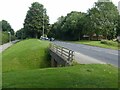
Subway under Arno Vale Road
Part of the A6211 which forms a major orbital link round the north east of Nottingham.
Image: © Alan Murray-Rust
Taken: 12 Aug 2021
0.22 miles
4
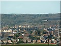
Somersby road
View as seen from the top of the hill at Somersby Road
Image: © Neil Packwood
Taken: 18 Jan 2009
0.22 miles
5
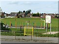
Arno Vale Recreation Ground
Open space alongside Arno Vale Road.
Image: © Alan Murray-Rust
Taken: 12 Aug 2021
0.24 miles