IMAGES TAKEN NEAR TO
Gedling Road, NOTTINGHAM, NG5 6NR
Introduction
This page details the photographs taken nearby to Gedling Road, NG5 6NR by members of the Geograph project.
The Geograph project started in 2005 with the aim of publishing, organising and preserving representative images for every square kilometre of Great Britain, Ireland and the Isle of Man.

There are currently over 7.5m images from over14,400 individuals and you can help contribute to the project by visiting https://www.geograph.org.uk
Image Map
Images are licensed for reuse under creativecommons.org/licenses/by-sa/2.0
Notes
- Clicking on the map will re-center to the selected point.
- The higher the marker number, the further away the image location is from the centre of the postcode.
Image Listing (23 Images Found)
Images are licensed for reuse under creativecommons.org/licenses/by-sa/2.0
Image
Details
Distance
1
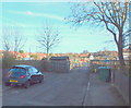
Arnold, NG5, Notts.
With most of this short road - Gedling Grove - behind the photographer, this is the gated entrance to the Gedling Grove Allotment site (a Borough of Gedling facility) at the closed end of the cul-de-sac.
Image: © David Hallam-Jones
Taken: 7 Mar 2014
0.04 miles
2
Arnold, NG5, Notts.
Inside the securely gated entrance of the Gedling Grove Allotment site. In 2008 there were 48 plots on this site however, a more recent demand for allotments persuaded Gedling Borough Council to divide some of the plots into two, thereby creating a larger number of smaller ones. One user told me that he had been allocated an allotment plot in 2010, after having been on the waiting list for the previous 6 years.
Image: © David Hallam-Jones
Taken: 7 Mar 2014
0.05 miles
3
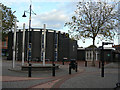
The Friar Tuck
Large 1930s style public house on the edge of Arnold Town Centre. The advertised meals for £2.99 appeared to be incredible value, even if the price shown was restricted to a small steak or fish with chips.
Image: © Alan Murray-Rust
Taken: 25 Oct 2009
0.07 miles
4
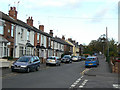
Worrall Avenue, Arnold
This shows an interesting progression of house styles as you get further along the road, clearly showing increasingly later dates of development.
Image: © Alan Murray-Rust
Taken: 25 Oct 2009
0.12 miles
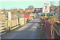
5

Gateway to King George V Recreation Ground
The gateway has been rebuilt in recent years, but incorporates the traditional memorial plaques associated with the George V playing fields scheme.
Image: © Alan Murray-Rust
Taken: 27 Jul 2016
0.13 miles
6
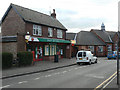
Arnold Post Office
Conveniently close to, but not on, the main shopping street, presumably to keep property costs down.
Image: © Alan Murray-Rust
Taken: 25 Oct 2009
0.13 miles
7
Market Office
At Arnold Market; it may look a little forlorn, but this was a Sunday.
Image: © Alan Murray-Rust
Taken: 25 Oct 2009
0.14 miles
8
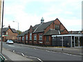
Methodist Church Hall
On Worrall Avenue, at the back of the Methodist Church.
Image: © Alan Murray-Rust
Taken: 25 Oct 2009
0.14 miles
9
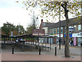
Arnold, The Market Place
As the notice indicates, the main open market is still held three times weekly, with additional weekly flea market and Trash & Treasure market.
The road name sign states 'The Market Place'.
Image: © Alan Murray-Rust
Taken: 25 Oct 2009
0.16 miles
10
Arnold Methodist Church
On the corner of The Market Place and Front Street.
Image: © Alan Murray-Rust
Taken: 25 Oct 2009
0.16 miles