IMAGES TAKEN NEAR TO
Jubilee Road, NOTTINGHAM, NG5 6JR
Introduction
This page details the photographs taken nearby to Jubilee Road, NG5 6JR by members of the Geograph project.
The Geograph project started in 2005 with the aim of publishing, organising and preserving representative images for every square kilometre of Great Britain, Ireland and the Isle of Man.

There are currently over 7.5m images from over14,400 individuals and you can help contribute to the project by visiting https://www.geograph.org.uk
Image Map
Images are licensed for reuse under creativecommons.org/licenses/by-sa/2.0
Notes
- Clicking on the map will re-center to the selected point.
- The higher the marker number, the further away the image location is from the centre of the postcode.
Image Listing (95 Images Found)
Images are licensed for reuse under creativecommons.org/licenses/by-sa/2.0
Image
Details
Distance
1
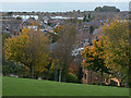
View from the park
Looking west from Arnot Hill Park towards Daybrook Square.
Image: © Alan Murray-Rust
Taken: 25 Oct 2009
0.00 miles
2
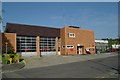
Arnold Fire Station
Arnold Fire Station, Jubilee Road, Arnold, forms part of the Nottinghamshire Fire & Rescue Service
Image: © Kevin Hale
Taken: 29 Apr 2007
0.02 miles
3
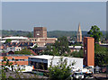
Daybrook
A view of Daybrook, taken from the former railway embankment east of B&Q. The two most prominent landmarks are the tower of the former Home Brewery (now Nottinghamshire County Council offices), designed by T Cecil Howitt, architect of Nottingham Council House, and the spire of St Paul's Church - "1892-6, by Pearson of Truro Cathedral, indeed with the same tall spire on the pattern of Coutances," according to Nikolaus Pevsner.
Image: © John Sutton
Taken: 18 May 2010
0.04 miles
4
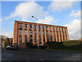
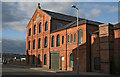
Former J and R Morley hosiery factory
The 1901 building http://www.britishlistedbuildings.co.uk/en-430399-former-j-and-r-morley-hosiery-factory-no#.VmXsQeKWMnA
Image: © Jonathan Thacker
Taken: 7 Dec 2015
0.04 miles
5
Barber shop on the corner of Morley Street
Image: © Jonathan Thacker
Taken: 7 Dec 2015
0.04 miles
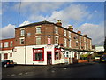
6
Daybrook: the barber shop on the corner of Morley Street
The former I & R Morley hosiery factory on the left is Grade II listed and according to the listing text "a particularly well-preserved group of late Victorian hosiery factories, each showing a major architectural and industrial development of this period". The Mansfield Road side of the building appears in Image
Image: © John Sutton
Taken: 2 May 2016
0.05 miles
7
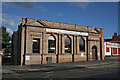
Former bank building, Daybrook Square
I have no idea which bank formerly owned this building.
Image: © Alan Murray-Rust
Taken: 22 Jun 2008
0.05 miles
8
Former J and R Morley hosiery factory
The original building http://www.britishlistedbuildings.co.uk/en-430399-former-j-and-r-morley-hosiery-factory-no#.VmXsQeKWMnA
Image: © Jonathan Thacker
Taken: 7 Dec 2015
0.06 miles
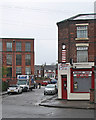
9
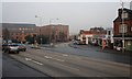
Junction of Nottingham Road with Mansfield Road
Nottingham Road is opposite heading to Arnold.
Image: © Mick Garratt
Taken: 23 Dec 2007
0.06 miles
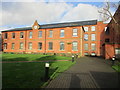
10
Morleys' Mill, Daybrook
A former textile factory, it later became a wire works and has now been converted to flats.
Image: © Alan Murray-Rust
Taken: 22 Jun 2008
0.06 miles