IMAGES TAKEN NEAR TO
Nottingham Road, NOTTINGHAM, NG5 6JN
Introduction
This page details the photographs taken nearby to Nottingham Road, NG5 6JN by members of the Geograph project.
The Geograph project started in 2005 with the aim of publishing, organising and preserving representative images for every square kilometre of Great Britain, Ireland and the Isle of Man.

There are currently over 7.5m images from over14,400 individuals and you can help contribute to the project by visiting https://www.geograph.org.uk
Image Map
Images are licensed for reuse under creativecommons.org/licenses/by-sa/2.0
Notes
- Clicking on the map will re-center to the selected point.
- The higher the marker number, the further away the image location is from the centre of the postcode.
Image Listing (46 Images Found)
Images are licensed for reuse under creativecommons.org/licenses/by-sa/2.0
Image
Details
Distance
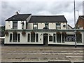
1
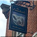
The sign of The Ernehale
Appears to depict a pair of bald eagles.
Image: © David Lally
Taken: 23 Aug 2018
0.02 miles
2
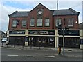
The Ernehale
Wetherspoons establishment.
Image: © David Lally
Taken: 23 Aug 2018
0.02 miles
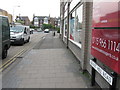
5
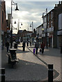
Front Street
The different textures of the pavement pick up a sudden burst of light through the clouds.
Image: © Alan Murray-Rust
Taken: 25 Oct 2009
0.05 miles
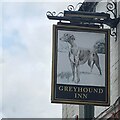
7
The Greyhound Inn
Nottingham Road, Arnold.
Image: © David Lally
Taken: 23 Aug 2018
0.06 miles
8
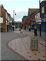
Pedestrianised Front Street
Looking north(ish) from the junction with High Street
Image: © Alan Murray-Rust
Taken: 25 Oct 2009
0.07 miles
9

High Street Avenue
General vehicle access from High Street is no longer permitted, although emergency and perhaps refuse collection vehicles can still make it over the moulded concrete blocks.
Image: © Alan Murray-Rust
Taken: 25 Oct 2009
0.09 miles
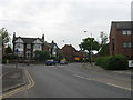
10
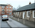
Charles Street, Arnold, Notts.
Facing Charles Street's junction with Nottingham Road. Nottingham Road is the one of the principal routes into Arnold's commercial heart. "The Old People's Welfare Centre" on the right was built in 1955 as a result of public generosity. It was provided "for the welfare of aged persons in Arnold and Daybrook and District, in perpetuity." It is also available for hire by community groups, e.g. a local amateur dramatic group uses it regularly to stage their productions.
Image: © David Hallam-Jones
Taken: 1 Jan 2016
0.09 miles