IMAGES TAKEN NEAR TO
Seagrave Court, NOTTINGHAM, NG5 6JA
Introduction
This page details the photographs taken nearby to Seagrave Court, NG5 6JA by members of the Geograph project.
The Geograph project started in 2005 with the aim of publishing, organising and preserving representative images for every square kilometre of Great Britain, Ireland and the Isle of Man.

There are currently over 7.5m images from over14,400 individuals and you can help contribute to the project by visiting https://www.geograph.org.uk
Image Map
Images are licensed for reuse under creativecommons.org/licenses/by-sa/2.0
Notes
- Clicking on the map will re-center to the selected point.
- The higher the marker number, the further away the image location is from the centre of the postcode.
Image Listing (47 Images Found)
Images are licensed for reuse under creativecommons.org/licenses/by-sa/2.0
Image
Details
Distance
1
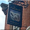
The sign of The Ernehale
Appears to depict a pair of bald eagles.
Image: © David Lally
Taken: 23 Aug 2018
0.05 miles
2
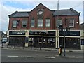
The Ernehale
Wetherspoons establishment.
Image: © David Lally
Taken: 23 Aug 2018
0.05 miles
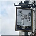
4
The Greyhound Inn
Nottingham Road, Arnold.
Image: © David Lally
Taken: 23 Aug 2018
0.06 miles
6

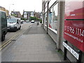
High Street Avenue
General vehicle access from High Street is no longer permitted, although emergency and perhaps refuse collection vehicles can still make it over the moulded concrete blocks.
Image: © Alan Murray-Rust
Taken: 25 Oct 2009
0.07 miles
8
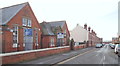
Church Drive, Arnold, Notts.
In 1895 the Arnold School Board commissioned a school for the accommodation of 420 girls comprising a central hall and seven class rooms. The cost was £4,700 and this school was opened in November 1896. It became a senior school in 1908 and older girls who had until been attending a school in High Street began attending here. The architect, William H. Higginbottom, was born in Leeds in 1868 but before he was 1 year old the family moved to Arnold following his father, Anthony's, appointment as the Headmaster of the British School on the site now occupied by the Arnold market. Anthony, it seems, was also something of an amateur draughtsman and his interest prompted his son to study and qualify as an architect and surveyor. William eventually opened an architectural practice with offices at 120 Front street, Arnold and 2, Friar Yard, Friar Lane, Nottingham. Apparently William designed a good many of Arnold's other well-known buildings. Prior to its closure - and conversion into a Business Centre - it was a mixed Primary School. This is a view towards where Church Drive and Church Drive East form the top bar of a T shape, this being the shaft of the T.
Image: © David Hallam-Jones
Taken: 12 Jan 2014
0.09 miles
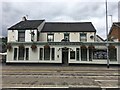
9
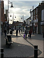
Front Street
The different textures of the pavement pick up a sudden burst of light through the clouds.
Image: © Alan Murray-Rust
Taken: 25 Oct 2009
0.09 miles
10
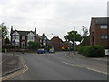
Charles Street, Arnold, Notts.
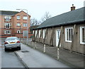
Facing Charles Street's junction with Nottingham Road. Nottingham Road is the one of the principal routes into Arnold's commercial heart. "The Old People's Welfare Centre" on the right was built in 1955 as a result of public generosity. It was provided "for the welfare of aged persons in Arnold and Daybrook and District, in perpetuity." It is also available for hire by community groups, e.g. a local amateur dramatic group uses it regularly to stage their productions.
Image: © David Hallam-Jones
Taken: 1 Jan 2016
0.10 miles