IMAGES TAKEN NEAR TO
Keats Close, NOTTINGHAM, NG5 6HB
Introduction
This page details the photographs taken nearby to Keats Close, NG5 6HB by members of the Geograph project.
The Geograph project started in 2005 with the aim of publishing, organising and preserving representative images for every square kilometre of Great Britain, Ireland and the Isle of Man.

There are currently over 7.5m images from over14,400 individuals and you can help contribute to the project by visiting https://www.geograph.org.uk
Image Map
Images are licensed for reuse under creativecommons.org/licenses/by-sa/2.0
Notes
- Clicking on the map will re-center to the selected point.
- The higher the marker number, the further away the image location is from the centre of the postcode.
Image Listing (47 Images Found)
Images are licensed for reuse under creativecommons.org/licenses/by-sa/2.0
Image
Details
Distance
1
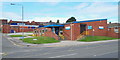
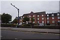
Daybrook, Nottingham NG5
Daybrook Health Centre at the junction of Salop Street with Mansfield Road (the A60).
Image: © David Hallam-Jones
Taken: 23 Aug 2014
0.11 miles
2
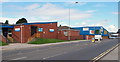
Daybrook, Nottingham NG5
The Daybrook Health Centre, together with some commercial premises, are seen here on the section of Mansfield Road (i.e. the A60) that approaches the busy Oxclose Lane (B6004) junction. The junction itself lies beyond the silvery-grey, single-storey car sales franchise in the distance.
Image: © David Hallam-Jones
Taken: 23 Aug 2014
0.11 miles
3
Mansfield Rd, Daybrook
Recreating this 'First' for the square http://www.geograph.org.uk/photo/35570 . I did not attempt to get to exactly the original camera position!
Image: © Alan Murray-Rust
Taken: 12 Aug 2021
0.11 miles
4
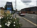
Roses beside Mansfield Road
Outside Wickes, Daybrook
In the distance the tower of the former Home brewery can be seen Image
Image: © David Lally
Taken: 14 Aug 2017
0.12 miles
5
Daybrook, Nottingham, NG5
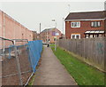
Home Close lies behind the photographer. This footpath at the side of a supermarket construction site - on land previously occupied by the former White Hart pub - empties out onto Oxclose Lane. The ground floor of the building ahead on Mansfield Road (the A60) was occupied by a Job Centre until mid-2014.
Image: © David Hallam-Jones
Taken: 21 Nov 2014
0.15 miles
7
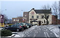
The Old Spot at Daybrook
An old former Coaching Inn now a Fayre and Square pub beside the Premier Inn Hotel at Daybrook. Reopened early 2011. Across the road are the Home Brewery Offices, until recently owned and used by Notts CC.
Image]
Image: © Richard Hoare
Taken: 6 Feb 2012
0.15 miles
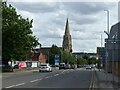
8
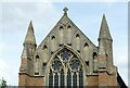
Church of St Paul, Daybrook - 2
The west window and gable; by the renowned late Victorian gothic-revival architect, J L Pearson. A mix of Early English and Decorated styles. Listed Grade II*.
Image: © Alan Murray-Rust
Taken: 12 Aug 2021
0.16 miles
9
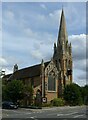
Church of St Paul, Daybrook - 1
A fine church, consecrated in 1895, by the renowned late Victorian gothic-revival architect, J L Pearson. A mix of Early English and Decorated styles. The tower and spire were added in 1897. Listed Grade II*
Image: © Alan Murray-Rust
Taken: 12 Aug 2021
0.16 miles
10
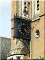
Church of St Paul, Daybrook - 4
The unusual bracket clock on the west face of the tower is a fine piece of wrought- and cast-iron work. Made by Gillet and Johnson of Croydon c.1900.
Image: © Alan Murray-Rust
Taken: 12 Aug 2021
0.16 miles