IMAGES TAKEN NEAR TO
Oxclose Lane, NOTTINGHAM, NG5 6FW
Introduction
This page details the photographs taken nearby to Oxclose Lane, NG5 6FW by members of the Geograph project.
The Geograph project started in 2005 with the aim of publishing, organising and preserving representative images for every square kilometre of Great Britain, Ireland and the Isle of Man.

There are currently over 7.5m images from over14,400 individuals and you can help contribute to the project by visiting https://www.geograph.org.uk
Image Map (Loading...)


Getting Data...Please wait
Leaflet Map data © OpenStreetMap
Images are licensed for reuse under creativecommons.org/licenses/by-sa/2.0
Notes
- Clicking on the map will re-center to the selected point.
- The higher the marker number, the further away the image location is from the centre of the postcode.
Image Listing (29 Images Found)
Images are licensed for reuse under creativecommons.org/licenses/by-sa/2.0
Image
Details
Distance
3
Chippenham Road
Looking down towards Edwards Lane.
Image: © Alan Murray-Rust
Taken: 15 Mar 2009
0.10 miles
4
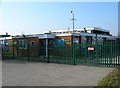
The Oxclose
A once popular pub serving the Bestwood estate. Now boarded up and looking forlorn.
Image: © Mick Garratt
Taken: 3 May 2008
0.10 miles
5
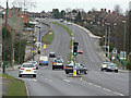
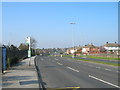
Oxclose Lane
East of Edwards Lane, the B6004 becomes Oxclose Lane and a dual carriageway. It is part of a major orbital route round north Nottingham.
Image: © Alan Murray-Rust
Taken: 15 Mar 2009
0.11 miles
6
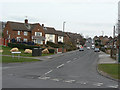
Chippenham Road
Part of the extensive Bestwood Park development from the 1950s onwards.
Image: © Alan Murray-Rust
Taken: 15 Mar 2009
0.11 miles
7
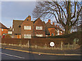
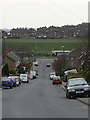
Corner semis on Edwards Lane Council Estate
This design appears to have been used across many Nottingham council estates between the mid-1920s through to the late 1940s (as here). Usually they occupy corner plots at junctions, with the two houses characteristically belonging to different streets. Earlier examples may be pebble-dashed or tile-hung rather than having exposed brickwork.
Image: © SK53
Taken: 4 Jan 2011
0.11 miles
8
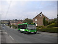
Bus ascending Chippenham Road
A 71 to Arnold climbs Chippenham Road in Bestwood Park estate.
Image: © Richard Vince
Taken: 3 Sep 2011
0.12 miles
10
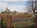
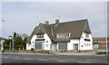
Site of former council housing off Rosecroft Drive
There were three blocks of maisonettes containing 36 dwellings (69-139 Rosecroft Drive) located here until around 2008.
The maisonettes are an unusual building type in the housing stock of Nottingham Borough Council. Existing examples are located on Abbey Bridge, Marchwood Close and Kibworth Court. I presume that the individual flats are single-aspect (i.e., back-to-back) given the size of the buildings, number of flats and doorways located on all sides of the building.
Image: © SK53
Taken: 4 Jan 2011
0.17 miles