IMAGES TAKEN NEAR TO
Kirtling Close, NOTTINGHAM, NG5 5TY
Introduction
This page details the photographs taken nearby to Kirtling Close, NG5 5TY by members of the Geograph project.
The Geograph project started in 2005 with the aim of publishing, organising and preserving representative images for every square kilometre of Great Britain, Ireland and the Isle of Man.

There are currently over 7.5m images from over14,400 individuals and you can help contribute to the project by visiting https://www.geograph.org.uk
Image Map
Images are licensed for reuse under creativecommons.org/licenses/by-sa/2.0
Notes
- Clicking on the map will re-center to the selected point.
- The higher the marker number, the further away the image location is from the centre of the postcode.
Image Listing (9 Images Found)
Images are licensed for reuse under creativecommons.org/licenses/by-sa/2.0
Image
Details
Distance
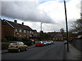
1
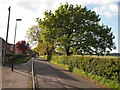
Nottingham - NG5 (Bestwood)
A stretch of Bestwood Lodge Drive looking in the direction of Bestwood Country Park and taken from Ellastone Avenue. The farm land beyond the hedge on the right-hand side is administered by Gedling Borough Council whilst Bestwood Park Estate on the left is administered by Nottingham City Council.
Image: © David Hallam-Jones
Taken: 16 May 2012
0.11 miles
2
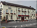
Old Spot Public House
On the Mansfield Road at Daybrook
Image: © Tom Courtney
Taken: 14 Apr 2004
0.15 miles
3
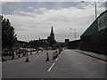
Mansfield Rd, Daybrook
Showing St Paul's Church and the square tower of the Old Home Brewery. At present they are re-surfacing the road ( A60 ).
Image: © Tom Courtney
Taken: 9 Aug 2005
0.15 miles
4
Nottingham - NG5 (Gedling)
A view of Bestwood Lodge Drive looking in the direction of Nottingham. Redhill Farm - on the left - is within the Gedling Borough Council administrative area, whereas Deer Park Drive is under the control of Nottingham City Council. The farm looks as though it is no longer functioning as a working farm.
Image: © David Hallam-Jones
Taken: 16 May 2012
0.17 miles
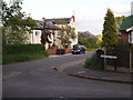
5
North end of Chippenham Road
The very north end of Chippenham Road, looking towards the junction with Queens Bower Road. This is in the later (eastern) part of Bestwood Park estate, which was built during the 1950s and 1960s; the housing here has a rather more modern look than that in the older parts of the estate.
Image: © Richard Vince
Taken: 23 Apr 2012
0.19 miles
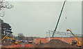
6
Daybrook, Nottingham, NG5
Construction work on a new 'economy supermarket' site on the former White Hart pub is seen here from Home Close. Home Close is a cul-de-sac and beyond the parked car terminates at the main entrance to Arnbrook Primary School. Ahead, the path empties out onto Oxclose Lane.
Image: © David Hallam-Jones
Taken: 21 Nov 2014
0.22 miles
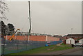
8
Daybrook, Nottingham, NG5
A view of construction work on the site of the former White Hart pub. This new building will be a new 'economy supermarket'. This picture was taken from a path between Maiden's Dale and Home Close. The A60 (the Nottingham-Mansfield road) lies beyond the distant blue security fencing.
Image: © David Hallam-Jones
Taken: 21 Nov 2014
0.23 miles
9
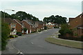
Deer Park Drive
1990s housing development off Bestwood Lodge Drive.
Image: © Alan Murray-Rust
Taken: 20 Jul 2010
0.24 miles