IMAGES TAKEN NEAR TO
Beckhampton Road, NOTTINGHAM, NG5 5SP
Introduction
This page details the photographs taken nearby to Beckhampton Road, NG5 5SP by members of the Geograph project.
The Geograph project started in 2005 with the aim of publishing, organising and preserving representative images for every square kilometre of Great Britain, Ireland and the Isle of Man.

There are currently over 7.5m images from over14,400 individuals and you can help contribute to the project by visiting https://www.geograph.org.uk
Image Map
Images are licensed for reuse under creativecommons.org/licenses/by-sa/2.0
Notes
- Clicking on the map will re-center to the selected point.
- The higher the marker number, the further away the image location is from the centre of the postcode.
Image Listing (42 Images Found)
Images are licensed for reuse under creativecommons.org/licenses/by-sa/2.0
Image
Details
Distance
1
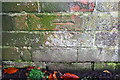
Benchmark on wall bounding #1 Pedmore Valley
Ordnance Survey cut mark benchmark described on the Bench Mark Database at http://www.bench-marks.org.uk/bm91946
Image: © Roger Templeman
Taken: 29 Nov 2017
0.07 miles
2
#1 Pedmore Valley
There is an OS benchmark Image on the brick wall about 18 inches from its junction with the hedge
Image: © Roger Templeman
Taken: 29 Nov 2017
0.07 miles
3
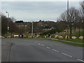
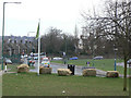
Sharp bend; Edwards Lane becomes Beckhampton Road
At this point it was intended that the main road should carry straight on. The land was reserved, but in the end the decision was made that it was not needed. The site remained open space and is now a protected Nature Reserve, Sandy Banks.
Image: © Alan Murray-Rust
Taken: 15 Mar 2009
0.08 miles
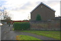
4
Scout Hut
On Edwards Lane, the headquarters of the 45th and 89th Nottingham Scout Group.
Image: © Alan Murray-Rust
Taken: 15 Mar 2009
0.08 miles
5
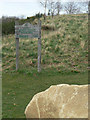
Sign at Sandy Banks
Shown as a Nature Area, but recently designated as a Reserve.
Sandy Banks is a fortuitous survival of natural landscape, due to it being reserved for a main road that was never built. Its website describes it as follows:
"Set in a green valley, it is a wildlife haven that would at one time have formed part of Sherwood Forest. It is situated 4 miles north of Nottingham City Centre in the Bestwood area of the city.
The site covers 5.9 hectares and is one of the few remaining wild sites within the City boundary. The high valley sides provide an excellent viewing point looking south towards the city centre.
The underlying Sandstone and free draining sandy soils give rise to conditions known as Lowland Dry Acid Grassland; this is a nationally rare habitat important for many kinds of invertebrates including beetles and solitary bees and wasps. The exposed areas of Sandstone and bare ground provide some of these insects with suitable areas for basking and burrowing.
There are also plantation woodlands, stands of broom, bracken and areas of neutral grassland which although common habitats, add interest and structural diversity to the site. The woodland and scrub areas provide nesting and feeding sites for a wide range of birds, including Linnet, Chiffchaff and Whitethroat."
For full details see http://www.nottinghamcity.gov.uk/index.aspx?articleid=3347
Image: © Alan Murray-Rust
Taken: 15 Mar 2009
0.08 miles
6
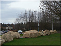
Protection for Sandy Banks
Heavy lumps of sandstone placed to prevent motor vehicles being driven onto a Nature Reserve.
Image: © Alan Murray-Rust
Taken: 15 Mar 2009
0.08 miles
7
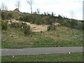
Sandy bank at Sandy Banks
It's clear how this urban nature Reserve has got its name; the Bunter Sandstone is very close to the surface. For more about the reserve, see Image
Image: © Alan Murray-Rust
Taken: 15 Mar 2009
0.09 miles
8
The top of Edwards Lane
Seen from Sandy Banks, looking south.
Image: © Alan Murray-Rust
Taken: 15 Mar 2009
0.12 miles
9
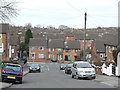
Hartcroft Road
Looking down to Beckhampton Road. The southern end of the postwar Bestwood Park Estate.
Image: © Alan Murray-Rust
Taken: 15 Mar 2009
0.12 miles
10
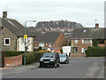
Stevenholme Crescent at Hartcroft Road
The trees on the skyline are on Glade Hill
Image: © Alan Murray-Rust
Taken: 15 Mar 2009
0.13 miles