IMAGES TAKEN NEAR TO
Ellastone Avenue, NOTTINGHAM, NG5 5RN
Introduction
This page details the photographs taken nearby to Ellastone Avenue, NG5 5RN by members of the Geograph project.
The Geograph project started in 2005 with the aim of publishing, organising and preserving representative images for every square kilometre of Great Britain, Ireland and the Isle of Man.

There are currently over 7.5m images from over14,400 individuals and you can help contribute to the project by visiting https://www.geograph.org.uk
Image Map
Images are licensed for reuse under creativecommons.org/licenses/by-sa/2.0
Notes
- Clicking on the map will re-center to the selected point.
- The higher the marker number, the further away the image location is from the centre of the postcode.
Image Listing (12 Images Found)
Images are licensed for reuse under creativecommons.org/licenses/by-sa/2.0
Image
Details
Distance
1
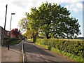
Nottingham - NG5 (Bestwood)
A stretch of Bestwood Lodge Drive looking in the direction of Bestwood Country Park and taken from Ellastone Avenue. The farm land beyond the hedge on the right-hand side is administered by Gedling Borough Council whilst Bestwood Park Estate on the left is administered by Nottingham City Council.
Image: © David Hallam-Jones
Taken: 16 May 2012
0.04 miles
2
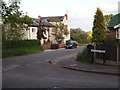
Nottingham - NG5 (Gedling)
A view of Bestwood Lodge Drive looking in the direction of Nottingham. Redhill Farm - on the left - is within the Gedling Borough Council administrative area, whereas Deer Park Drive is under the control of Nottingham City Council. The farm looks as though it is no longer functioning as a working farm.
Image: © David Hallam-Jones
Taken: 16 May 2012
0.08 miles
3
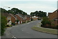
Deer Park Drive
1990s housing development off Bestwood Lodge Drive.
Image: © Alan Murray-Rust
Taken: 20 Jul 2010
0.18 miles
5
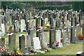
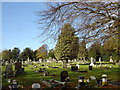
Redhill Cemetery
View of the northern section.
Image: © Alan Murray-Rust
Taken: 20 Jul 2010
0.19 miles
6
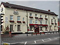
Old Spot Public House
On the Mansfield Road at Daybrook
Image: © Tom Courtney
Taken: 14 Apr 2004
0.23 miles
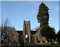
7
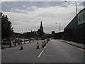
Mansfield Rd, Daybrook
Showing St Paul's Church and the square tower of the Old Home Brewery. At present they are re-surfacing the road ( A60 ).
Image: © Tom Courtney
Taken: 9 Aug 2005
0.23 miles
8
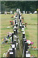
Gravestones, Redhill Cemetery
Many of these are having to be supported by straps to prevent them falling over.
Image: © Alan Murray-Rust
Taken: 20 Jul 2010
0.23 miles
10
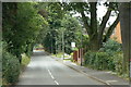
Bestwood Lodge Drive
Once just what the name implies, but now giving access to quite a lot of housing development.
Image: © Alan Murray-Rust
Taken: 20 Jul 2010
0.24 miles