IMAGES TAKEN NEAR TO
Blyton Walk, NOTTINGHAM, NG5 5NW
Introduction
This page details the photographs taken nearby to Blyton Walk, NG5 5NW by members of the Geograph project.
The Geograph project started in 2005 with the aim of publishing, organising and preserving representative images for every square kilometre of Great Britain, Ireland and the Isle of Man.

There are currently over 7.5m images from over14,400 individuals and you can help contribute to the project by visiting https://www.geograph.org.uk
Image Map
Images are licensed for reuse under creativecommons.org/licenses/by-sa/2.0
Notes
- Clicking on the map will re-center to the selected point.
- The higher the marker number, the further away the image location is from the centre of the postcode.
Image Listing (20 Images Found)
Images are licensed for reuse under creativecommons.org/licenses/by-sa/2.0
Image
Details
Distance
1
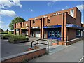
Beckhampton Shopping Parade
A small shopping precinct on the northern edge of the Bestwood estate. Well “stocked” with functioning shops and clean and tidy.
Image: © David Lally
Taken: 4 Jul 2024
0.09 miles
2
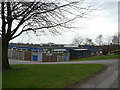
Bestwood Park Health Centre
Adjacent to the main shopping precinct for the Bestwood Park Estate.
Image: © Alan Murray-Rust
Taken: 15 Mar 2009
0.09 miles
3
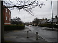
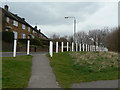
Beckhampton Road, Bestwood Park estate
Beckhampton Road traverses Bestwood Park estate basically from north to south, but winds around so much on the way that this view was taken facing almost due west. The housing on the right, including some bungalows, is typical of this part of the estate, which was built in the 1950s if memory serves. The flats on the left are of more recent construction, and probably date from the same period as the shopping precinct immediately to their east (see Image).
Image: © Richard Vince
Taken: 13 Apr 2013
0.10 miles
4
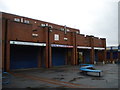
Elmbridge shopping precinct, Bestwood Park estate
Located just off Beckhampton Road, one of the main distributors in Bestwood Park estate, this precinct usually seems to be quite busy, but I found most of the shops had already closed when I arrived just after five on a Saturday afternoon.
Image: © Richard Vince
Taken: 13 Apr 2013
0.11 miles
6
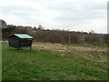
Sandy Banks Nature Reserve
The reserve has to double as a local recreational area, including a portion set out as a small rough bike track. The shelter appears to have been provided as part of this.
For more about the reserve, see Image
Image: © Alan Murray-Rust
Taken: 15 Mar 2009
0.13 miles
7
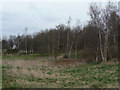
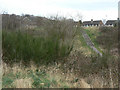
Sandy Banks Nature Reserve
The dry, relatively infertile substrate of the area - Bunter Sandstone - is evidenced by the growth, with birch being the predominant tree species.
For more about the reserve, see Image
Image: © Alan Murray-Rust
Taken: 15 Mar 2009
0.14 miles
8
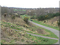
Sandy Banks Nature Reserve
Looking down the site showing the variety of vegetation including Broom and Gorse.
For more about the reserve, see Image
Image: © Alan Murray-Rust
Taken: 15 Mar 2009
0.14 miles
9
Chiltern Way
Housing on the edge of Sandy Banks Nature Reserve. The reserve survives despite being a major pedestrian route with no particular protection for the vegetation.
For more about the reserve, see Image
Image: © Alan Murray-Rust
Taken: 15 Mar 2009
0.15 miles
10
Sandy Banks Nature Reserve
Bramble, Broom and thorn are among the scrub vegetations visible here.
For more about the reserve, see Image
Image: © Alan Murray-Rust
Taken: 15 Mar 2009
0.15 miles