IMAGES TAKEN NEAR TO
Carnwood Road, NOTTINGHAM, NG5 5HW
Introduction
This page details the photographs taken nearby to Carnwood Road, NG5 5HW by members of the Geograph project.
The Geograph project started in 2005 with the aim of publishing, organising and preserving representative images for every square kilometre of Great Britain, Ireland and the Isle of Man.

There are currently over 7.5m images from over14,400 individuals and you can help contribute to the project by visiting https://www.geograph.org.uk
Image Map
Images are licensed for reuse under creativecommons.org/licenses/by-sa/2.0
Notes
- Clicking on the map will re-center to the selected point.
- The higher the marker number, the further away the image location is from the centre of the postcode.
Image Listing (48 Images Found)
Images are licensed for reuse under creativecommons.org/licenses/by-sa/2.0
Image
Details
Distance
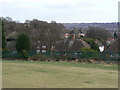
1
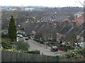
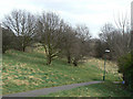
Carnwood Road
Looking down from the former Padstow School grounds.
Image: © Alan Murray-Rust
Taken: 15 Mar 2009
0.03 miles
2
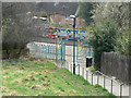
Entrance to Sunrise Hill
Attractive modern gateway off Landcroft Crescent into this small Nature Reserve in the middle of urban development.
Image: © Alan Murray-Rust
Taken: 15 Mar 2009
0.03 miles
3
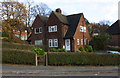
#56 Carnwood Road and #31 Landcroft Crescent
There is an OS benchmark Image on the near corner, right hand face, of the right hand house
Image: © Roger Templeman
Taken: 29 Nov 2017
0.05 miles
4
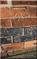
Benchmark on #56 Carnwood Road
Ordnance Survey cut mark benchmark described on the Bench Mark Database at http://www.bench-marks.org.uk/bm91949
Image: © Roger Templeman
Taken: 29 Nov 2017
0.05 miles
5
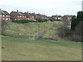
Sunrise Hill
Open space which has survived largely due to the very steep slope in the middle of urban development. Now a designated nature reserve. http://www.nottinghamcity.gov.uk/index.aspx?articleid=3339
Image: © Alan Murray-Rust
Taken: 15 Mar 2009
0.06 miles
6
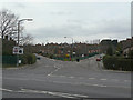
Gainsford Crescent
The east junction of Gainsford Crescent with Arnold Road is complicated by the presence of Carnwood Road. This used to run straight down as can be seen by the old pavement line.
Image: © Alan Murray-Rust
Taken: 15 Mar 2009
0.06 miles
7
Footpath to Sunrise Hill
The land in the foreground forms the grounds of the former Padstow School, hence the fence and the brak in the footpath. The area is now accessible as open space.
Image: © Alan Murray-Rust
Taken: 15 Mar 2009
0.07 miles
8
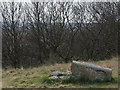
Sunrise Hill triangulation point
Even without the damage to the pillar, observation would have been difficult without serious tree removal. From here the distant blue horizon visible through the trees is somewhere out towards Breedon Hill Image
Image: © Alan Murray-Rust
Taken: 15 Mar 2009
0.07 miles
9
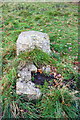
Remains on trig pillar on Sunrise Hill
The brass bolt on the base section of the pillar can be seen at the centre foreground. For more information on the pillar see http://trigpointing.uk/trig/6263.
Image: © Roger Templeman
Taken: 28 Nov 2017
0.07 miles
10
The back of Landcroft Crescent
The sharp fall of the hillside at this point made a natural boundary for the housing estates of the 1930s. The open space in the foreground was part of the former Padstow School grounds.
Image: © Alan Murray-Rust
Taken: 15 Mar 2009
0.07 miles