IMAGES TAKEN NEAR TO
Andover Road, NOTTINGHAM, NG5 5FG
Introduction
This page details the photographs taken nearby to Andover Road, NG5 5FG by members of the Geograph project.
The Geograph project started in 2005 with the aim of publishing, organising and preserving representative images for every square kilometre of Great Britain, Ireland and the Isle of Man.

There are currently over 7.5m images from over14,400 individuals and you can help contribute to the project by visiting https://www.geograph.org.uk
Image Map
Images are licensed for reuse under creativecommons.org/licenses/by-sa/2.0
Notes
- Clicking on the map will re-center to the selected point.
- The higher the marker number, the further away the image location is from the centre of the postcode.
Image Listing (16 Images Found)
Images are licensed for reuse under creativecommons.org/licenses/by-sa/2.0
Image
Details
Distance
1
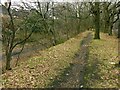
Alongside the Hucknall Road Walkway
The walkway is in the bottom of the railway cutting, which typically has been populated with sycamore trees. However, the top of the bank retains a line of mature oak trees which formed a windbreak alongside Hucknall Road prior to the construction of the railway in the late 19th century.
Image: © Alan Murray-Rust
Taken: 8 Feb 2022
0.09 miles
2
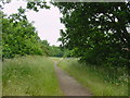
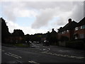
Old Railway Line
Footpath along the old railway line parallel to A611
Image: © Q
Taken: 15 Jun 2005
0.11 miles
3

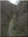
Hucknall Road Walkway
On the trackbed of the former Great Northern Railway's Leen Valley branch. The walkway also provides an important wildlife corridor.
Image: © Alan Murray-Rust
Taken: 8 Feb 2022
0.16 miles
4
Railway trail
Footpath on the alignment of the old GNR Leen Valley branch railway seen from Arnold Road bridge.
Image: © Alan Murray-Rust
Taken: 15 Mar 2009
0.16 miles
5
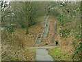
The site of Marble Arch
This was the local name given to a farm track accommodation bridge under the railway, later providing pedestrian access into Bestwood Estate. It was a tall narrow brick arch of similar proportions to the central opening of the London monument, hence the name. It was quite dark and was demolished following the closure of the railway, the line of which is now the Hucknall Road Walkway. The Walkway is a multi-user route; there is an alternative ramp to the left of the embankment - cyclists don't have to use the steps!
Image: © Alan Murray-Rust
Taken: 8 Feb 2022
0.16 miles
6

Cycle trail on former railway beside the A611
Image: © JThomas
Taken: 17 Apr 2010
0.21 miles
7
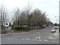
Gainsford Crescent junction
The western junction with Arnold Road. Andover Road (left) used to come straight out at this junction which has been substantially re-modelled to improve traffic flows.
Image: © Alan Murray-Rust
Taken: 15 Mar 2009
0.21 miles
9
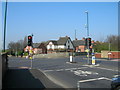
Junction of Arnold Road (B6004) and Hucknall Road (A611)
Image: © JThomas
Taken: 17 Apr 2010
0.23 miles
10
Arnold Road, former railway bridge
There is a benchmark https://www.geograph.org.uk/photo/7107243 on the parapet just to the left of the lighting column.
Image: © Alan Murray-Rust
Taken: 8 Feb 2022
0.24 miles