IMAGES TAKEN NEAR TO
Casterton Road, NOTTINGHAM, NG5 5ER
Introduction
This page details the photographs taken nearby to Casterton Road, NG5 5ER by members of the Geograph project.
The Geograph project started in 2005 with the aim of publishing, organising and preserving representative images for every square kilometre of Great Britain, Ireland and the Isle of Man.

There are currently over 7.5m images from over14,400 individuals and you can help contribute to the project by visiting https://www.geograph.org.uk
Image Map
Images are licensed for reuse under creativecommons.org/licenses/by-sa/2.0
Notes
- Clicking on the map will re-center to the selected point.
- The higher the marker number, the further away the image location is from the centre of the postcode.
Image Listing (19 Images Found)
Images are licensed for reuse under creativecommons.org/licenses/by-sa/2.0
Image
Details
Distance
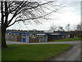
1
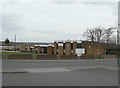
Bestwood Park Church
This is an ecumenidal church serving both Anglican and Methodist congregations, and appears to have no dedication.
Image: © Alan Murray-Rust
Taken: 15 Mar 2009
0.09 miles
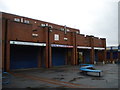
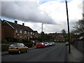
3
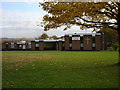
Bestwood Housing Office
Serving the large council developments of Bestwood and Bestwood Park.
Image: © Alan Murray-Rust
Taken: 15 Mar 2009
0.09 miles
5
Elmbridge shopping precinct, Bestwood Park estate
Located just off Beckhampton Road, one of the main distributors in Bestwood Park estate, this precinct usually seems to be quite busy, but I found most of the shops had already closed when I arrived just after five on a Saturday afternoon.
Image: © Richard Vince
Taken: 13 Apr 2013
0.14 miles
6
Beckhampton Shopping Parade
A small shopping precinct on the northern edge of the Bestwood estate. Well “stocked” with functioning shops and clean and tidy.
Image: © David Lally
Taken: 4 Jul 2024
0.15 miles
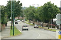
7
Beckhampton Road, Bestwood Park estate
Beckhampton Road traverses Bestwood Park estate basically from north to south, but winds around so much on the way that this view was taken facing almost due west. The housing on the right, including some bungalows, is typical of this part of the estate, which was built in the 1950s if memory serves. The flats on the left are of more recent construction, and probably date from the same period as the shopping precinct immediately to their east (see Image).
Image: © Richard Vince
Taken: 13 Apr 2013
0.15 miles
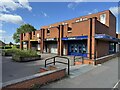
8
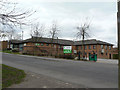
Bestwood Park Health Centre
Adjacent to the main shopping precinct for the Bestwood Park Estate.
Image: © Alan Murray-Rust
Taken: 15 Mar 2009
0.16 miles
9
North end of Chippenham Road
The very north end of Chippenham Road, looking towards the junction with Queens Bower Road. This is in the later (eastern) part of Bestwood Park estate, which was built during the 1950s and 1960s; the housing here has a rather more modern look than that in the older parts of the estate.
Image: © Richard Vince
Taken: 23 Apr 2012
0.19 miles
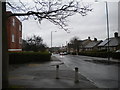
10
Bestwood Park Drive
Looking south east from Deer Park Drive. this is part of an important orbital route round the north of Nottingham, linking Bulwell with Arnold.
Image: © Alan Murray-Rust
Taken: 20 Jul 2010
0.20 miles