IMAGES TAKEN NEAR TO
Dunvegan Drive, NOTTINGHAM, NG5 5DX
Introduction
This page details the photographs taken nearby to Dunvegan Drive, NG5 5DX by members of the Geograph project.
The Geograph project started in 2005 with the aim of publishing, organising and preserving representative images for every square kilometre of Great Britain, Ireland and the Isle of Man.

There are currently over 7.5m images from over14,400 individuals and you can help contribute to the project by visiting https://www.geograph.org.uk
Image Map
Images are licensed for reuse under creativecommons.org/licenses/by-sa/2.0
Notes
- Clicking on the map will re-center to the selected point.
- The higher the marker number, the further away the image location is from the centre of the postcode.
Image Listing (26 Images Found)
Images are licensed for reuse under creativecommons.org/licenses/by-sa/2.0
Image
Details
Distance
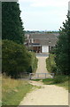
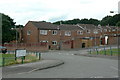
1
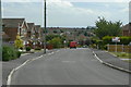
Dunvegan Drive
The eastern end of Rise Park Estate, looking across to Top Valley.
Image: © Alan Murray-Rust
Taken: 20 Jul 2010
0.04 miles
2
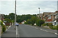
Cuillin Close
Cul-de-sac at the north eastern corner of Rise Park Estate. Names are associated with the Isle of Skye.
Image: © Alan Murray-Rust
Taken: 20 Jul 2010
0.06 miles
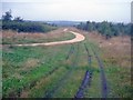
3
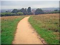
Path to Rise Park
Heading south-west to the boundary of Bestwood Country Park.
Image: © Trevor Rickard
Taken: 1 Aug 2009
0.08 miles
4
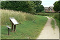
Information board
At the entrance to Bestwood Country Park from Rise Park Estate.
Image: © Alan Murray-Rust
Taken: 20 Jul 2010
0.08 miles
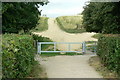
5
Exit from Bestwood Country Park
The way out into Rise Park Estate. The park was created in part from the spoil heap of Bestwood Colliery.
Image: © Alan Murray-Rust
Taken: 20 Jul 2010
0.08 miles
6
Entrance to Bestwood Country Park
This part of the park was developed on the former spoil heap of Bestwood Colliery.
Image: © Alan Murray-Rust
Taken: 20 Jul 2010
0.09 miles
7
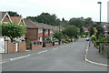
Bracadale Road
The most easterly road in Rise Park Estate.
Image: © Alan Murray-Rust
Taken: 20 Jul 2010
0.11 miles
8
High-level path at Bestwood Country Park - 1
View west along the path, which snakes between two stands of woodland. The surfaced path is a designated horse-riding route.
Image: © Trevor Rickard
Taken: 1 Aug 2009
0.13 miles
9
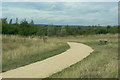
Pathway in Bestwood Country Park
This part of the park is the reclaimed spoil tip of Bestwood Colliery.
Image: © Alan Murray-Rust
Taken: 20 Jul 2010
0.13 miles
10
Northern names
Vehicle access to several of the closes off Bewcastle Road. As can be seen, the names all have associations with the north east of England.
Image: © Alan Murray-Rust
Taken: 20 Jul 2010
0.16 miles