IMAGES TAKEN NEAR TO
Houston Close, NOTTINGHAM, NG5 5DQ
Introduction
This page details the photographs taken nearby to Houston Close, NG5 5DQ by members of the Geograph project.
The Geograph project started in 2005 with the aim of publishing, organising and preserving representative images for every square kilometre of Great Britain, Ireland and the Isle of Man.

There are currently over 7.5m images from over14,400 individuals and you can help contribute to the project by visiting https://www.geograph.org.uk
Image Map
Images are licensed for reuse under creativecommons.org/licenses/by-sa/2.0
Notes
- Clicking on the map will re-center to the selected point.
- The higher the marker number, the further away the image location is from the centre of the postcode.
Image Listing (26 Images Found)
Images are licensed for reuse under creativecommons.org/licenses/by-sa/2.0
Image
Details
Distance
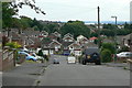
1
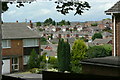
Rise Park
View northwest across the estate from Bestwood Park Drive West.
Image: © Alan Murray-Rust
Taken: 20 Jul 2010
0.04 miles
2
Bestwood Park Drive West
Looking down the hill towards Bulwell. Compare how the trees have grown in the 25 years since this image http://www.geograph.org.uk/photo/2004885 was taken
Image: © Alan Murray-Rust
Taken: 14 Jun 1986
0.09 miles
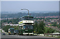
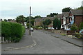
3
Bestwood Park Drive West
Looking down the hill towards Bulwell. Note how tree growth has reduced the visual impact of urban development since this 1986 view http://www.geograph.org.uk/photo/2004889 .
Image: © Alan Murray-Rust
Taken: 20 Jul 2010
0.10 miles
5
Roseneath Avenue
Looking south from Brownlow Drive.
Image: © Alan Murray-Rust
Taken: 20 Jul 2010
0.11 miles
6
Crowthorne Close
Typical road in the Rise Park Estate.
Image: © Alan Murray-Rust
Taken: 20 Jul 2010
0.12 miles
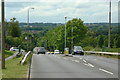
7
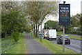
Speed indicator on Bestwood Park Drive West
Image: © David Lally
Taken: 27 Apr 2017
0.13 miles
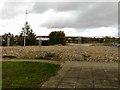
8

Academy Day Nursery
Built on the site of a petrol filling station.
Image: © Alan Murray-Rust
Taken: 20 Jul 2010
0.13 miles
9
Langbank Avenue
This marks the southern limit of the original Rise Park development, readily discernable on maps. See the description on this image http://www.geograph.org.uk/photo/2004844
Image: © Alan Murray-Rust
Taken: 20 Jul 2010
0.14 miles
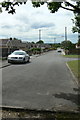
10
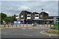
Rise Park shops
The left hand unit includes the local Post Office.
Image: © Alan Murray-Rust
Taken: 20 Jul 2010
0.15 miles